Category:1920s maps of Turkey
Countries of Asia: Armenia‡ · Azerbaijan‡ · Cambodia · People's Republic of China · Egypt‡ · Georgia‡ · India · Indonesia‡ · Iran · Iraq · Israel · Japan · Jordan · Laos · Lebanon · Mongolia · Philippines · Russia‡ · Syria · Turkey‡ · Vietnam
Limited recognition: Taiwan · State of Palestine
‡: partly located in Asia
Limited recognition: Taiwan · State of Palestine
‡: partly located in Asia
Countries of Europe: Albania · Armenia‡ · Austria · Azerbaijan‡ · Belarus · Belgium · Bosnia and Herzegovina · Bulgaria · Croatia · Czech Republic · Denmark · Estonia · Finland · France‡ · Georgia‡ · Germany · Greece · Hungary · Iceland · Republic of Ireland · Italy · Latvia · Lithuania · Luxembourg · Montenegro · Netherlands‡ · Norway · Poland · Portugal‡ · Romania · Russia‡ · Serbia · Slovenia · Spain‡ · Sweden · Switzerland · Turkey‡ · Ukraine · United Kingdom
‡: partly located in Europe
‡: partly located in Europe
Subcategories
This category has the following 3 subcategories, out of 3 total.
- 1920 maps of Turkey (9 F)
- 1923 maps of Turkey (3 F)
*
- 1920s maps of Istanbul (9 F)
Media in category "1920s maps of Turkey"
The following 14 files are in this category, out of 14 total.
-
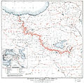 Boundary between Turkey and Armenia as determined by Woodrow Wilson.jpg 8,953 × 8,820; 42.55 MB
-
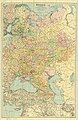 1921 map of Russia.jpg 7,448 × 11,500; 16.51 MB
-
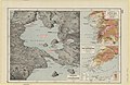 1922 map of the Dardanelles, Sea of Marmara and the Bosporus.jpg 5,000 × 3,264; 11.14 MB
-
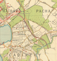 Bagdat Caddesi Map.png 1,063 × 1,129; 2.41 MB
-
 Ca. 1922 map of the Sea of Marmara (cropped).tif 4,776 × 4,716; 64.46 MB
-
 Ca. 1922 map of the Sea of Marmara and the Turkish Straits.tif 8,780 × 5,733; 144.04 MB
-
 Istanbul PU945.jpg 5,639 × 7,087; 5.66 MB
-
 Istanbul PU946.jpg 3,684 × 3,499; 2.42 MB
-
 Istanbul PU971 cropped armenian cemetery.jpg 814 × 1,009; 295 KB
-
 Istanbul PU971.jpg 5,573 × 3,879; 3.94 MB
-
 TreatyofKarsMap.jpg 1,000 × 864; 404 KB
-
 1925 Air Routes in Western Anatolia.jpg 653 × 921; 159 KB
-
 Ana Vatan - (Turkey). LOC 2010593205.tif 15,793 × 10,476; 473.38 MB
-


_(14802555663).jpg)