Category:1944 maps of the world
Media in category "1944 maps of the world"
The following 19 files are in this category, out of 19 total.
-
 1944 map of the world showing events of World War II.jpg 7,000 × 3,085; 5.4 MB
-
 A land for the Jews, 1944.jpg 1,974 × 1,530; 734 KB
-
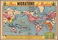 Mass migrations of mankind, 1944.jpg 2,190 × 1,538; 643 KB
-
 Mercator map of the world united (35048889281).jpg 2,000 × 868; 2.02 MB
-

-
 NavWarMap No. 6 - We Fight a Global War.jpg 8,500 × 5,782; 6.09 MB
-
 One war, seven fronts.jpg 969 × 496; 179 KB
-
 One World, One war (1944).jpg 5,501 × 3,492; 2.55 MB
-

-
 Port of Seattle Victory Book, 1944.jpg 2,550 × 3,300; 4.16 MB
-
 Principal ocean cables, 1944.jpg 1,442 × 880; 356 KB
-
 The Star Weekly Map of the World at War, 1944.jpg 1,854 × 1,282; 1.04 MB
-
 The story map of flying (35048880341).jpg 1,525 × 2,000; 2.96 MB
-
 The story map of flying - being a chronicle of man's conquest of the air.tif 5,368 × 7,040; 108.15 MB
-
 The trans-orbal map - a Global Press map for one world LOC 88693537.jpg 7,937 × 12,003; 8.14 MB
-
 The trans-orbal map - a Global Press map for one world LOC 88693537.tif 7,937 × 12,003; 272.56 MB
-
 The World, 1944.jpg 13,409 × 7,317; 10.08 MB
-
 World Island, 1944.jpg 5,136 × 3,283; 2.52 MB
-
 World Map of the Major Tropical Diseases.jpg 12,369 × 8,345; 24.29 MB


.jpg)


.jpg)


.jpg)


