Category:1947 maps of the world
Media in category "1947 maps of the world"
The following 19 files are in this category, out of 19 total.
-
 1947 Equidistant Chart of the World Centered on the United States.jpg 12,664 × 14,157; 23.46 MB
-
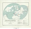
 1947 Land Hemisphere map.jpg 9,500 × 8,435; 14.79 MB
-
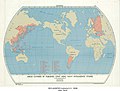
 AGS World map 1947.jpg 8,839 × 5,566; 4.17 MB
-

-
-
-
 Iron ore reserves - World - Department of State, map division - btv1b53196974f.jpg 10,582 × 7,650; 9.81 MB
-
 Non-Self-governing and Trust Territories - DPLA - 9b5466c10ea498a2ee9c3742cf10885d.jpg 7,022 × 2,963; 2.01 MB
-
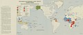 Non-Self-governing and Trust Territories, 1947.jpg 6,516 × 2,743; 3.8 MB
-
 Panam 1947.jpg 2,870 × 1,603; 981 KB
-
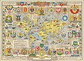
 The pictorial map - a world of stamps.tif 6,702 × 4,360; 83.63 MB
-
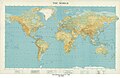
 The World - DPLA - 06e18dc94b012a37094e20cef473ca5e.jpg 17,168 × 11,340; 24.99 MB
-
 The World - DPLA - 35a0ff3930f197597e1d42356b2f1c41.jpg 17,102 × 11,340; 10.73 MB
-
 The World - DPLA - de12bdff7faca752f7e7788fb5fae04f.jpg 17,136 × 11,183; 22.91 MB
-
-
 United Kingdom and Portugal Bilateral Air Transport Rights, 1947.jpg 6,912 × 5,946; 4.62 MB
-
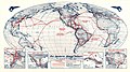
 United Nations Map of the World.jpg 11,103 × 8,188; 23.92 MB
-
 United States of America and the United Kingdom Bilateral Air Transport Rights, 1947.jpg 12,036 × 7,048; 5.39 MB
-
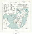
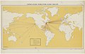 United States World-Wide Radio Circuits - Department of State, Map Division - btv1b53196908b.jpg 11,226 × 7,074; 6.44 MB


