Category:1982 United States Senate election maps
Media in category "1982 United States Senate election maps"
The following 46 files are in this category, out of 46 total.
-
 1982 Arizona.png 2,000 × 2,332; 215 KB
-
 1982 California Senate Counties.png 2,834 × 4,275; 729 KB
-
 1982 MA Senate.png 2,400 × 1,492; 116 KB
-
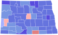 1982 nd senate.svg 810 × 488; 28 KB
-
 1982 NV.png 2,000 × 3,110; 241 KB
-

-

-

-
-

-
 1982 United States Senate election in Hawaii results map by county.svg 1,052 × 614; 2.12 MB
-

-

-
 1982 United States Senate election in Maryland results map by county.svg 744 × 405; 222 KB
-
 1982 United States Senate Election in Massachusetts by Town.svg 810 × 502; 182 KB
-

-
 1982 United States Senate election in Massachusetts results map by municipality.svg 2,100 × 1,300; 1.56 MB
-
 1982 United States Senate election in Michigan results map by county.svg 744 × 744; 309 KB
-
-

-

-

-

-

-

-

-
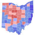 1982 United States Senate election in Ohio results map by county.svg 810 × 810; 39 KB
-

-

-

-

-

-
 1982 United States Senate election in Utah results map by county.svg 810 × 810; 29 KB
-
-
-

-

-

-

-
 1982 United States Senate elections results map.svg 959 × 593; 82 KB
-
 1982 virginia senate election map.png 833 × 364; 34 KB
-
 Delaware Senate Election Results by County, 1982.svg 108 × 211; 4 KB
-
 Nebraska Senate Election Results by County, 1982.svg 282 × 133; 26 KB
-
 NewYork 1982 Senate Election.gif 342 × 263; 6 KB
-
 Ohio 1982 Senate Election.gif 198 × 214; 7 KB
-
 Washington Senate Election Results by County, 1982.svg 744 × 497; 372 KB


