Category:Aerial photographs of Landkreis Augsburg
Urban districts (cities): Amberg · Ansbach · Aschaffenburg · Augsburg · Bamberg · Bayreuth · Coburg · Erlangen · Fürth · Hof · Kaufbeuren · Kempten · Landshut · Memmingen · Munich · Nuremberg · Passau · Regensburg · Rosenheim · Schwabach · Straubing · Weiden in der Oberpfalz · Würzburg
Deutsch: Luftaufnahmen aus dem Landkreis Augsburg.
Subcategories
This category has only the following subcategory.
Media in category "Aerial photographs of Landkreis Augsburg"
The following 12 files are in this category, out of 12 total.
-
 Aerial image of the Augsburg-Gablingen prison (view from the southeast).jpg 5,000 × 3,000; 5.86 MB
-
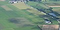 Aerial image of the Schwabmünchen airfield.jpg 4,300 × 2,200; 2.99 MB
-
 Amazon.de 1204 - panoramio.jpg 2,884 × 1,591; 1.17 MB
-
 Augsburg Orthophoto.jpg 1,280 × 1,332; 739 KB
-
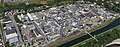
 BND-Außenstelle Gablingen.jpg 3,072 × 2,304; 2.32 MB
-
 ETSL AIRPORT LECHFELD AIR FORCE BASE FROM A319 F-GRXD FLIGHT MUC-CDG (14986026624).jpg 2,065 × 1,377; 477 KB
-
 Flug -Rom-Düsseldorf-Hamburg 2013 by-RaBoe 202.jpg 3,172 × 2,107; 1.04 MB
-
 Flug Frankfurt Sofia 072.JPG 4,272 × 2,848; 5.63 MB
-
 Flughafen Augsburg Flug Frankfurt Sofia 075.jpg 4,272 × 2,848; 5.55 MB
-
 Luftaufnahme Ausschnitt.jpg 3,161 × 1,238; 3.31 MB
-
 Luftbild - Schwabmünchen - Angriffsziele - 1945.jpg 1,200 × 674; 171 KB
-
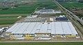
 Luftfoto Humbaur.jpg 800 × 341; 257 KB
.jpg)


.jpg)


