Category:Aerial photographs of Landkreis Fürth
Urban districts (cities): Amberg · Ansbach · Aschaffenburg · Augsburg · Bamberg · Bayreuth · Coburg · Erlangen · Fürth · Hof · Kaufbeuren · Kempten · Landshut · Memmingen · Munich · Nuremberg · Passau · Regensburg · Rosenheim · Schwabach · Straubing · Weiden in der Oberpfalz · Würzburg
Deutsch: Luftaufnahmen aus dem Landkreis Fürth.
Subcategories
This category has only the following subcategory.
Media in category "Aerial photographs of Landkreis Fürth"
The following 18 files are in this category, out of 18 total.
-
 Aerial image of the Fürth-Seckendorf gliding site.jpg 4,300 × 3,300; 6.79 MB
-
 Cadolzburg Ortskern Panorama (2020).jpg 3,214 × 1,691; 3.56 MB
-
 Cadolzburg Panorama von Süden Luftaufnahme (2020).jpg 5,222 × 2,221; 6.9 MB
-
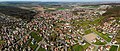
 Cadolzburg von Süden Luftaufnahme (2020).jpg 4,056 × 3,040; 6 MB
-
 Fürth Sportanlage Charly Mai.jpg 4,000 × 2,250; 3.75 MB
-
 Fürth, Kapellenstrasse.jpg 4,000 × 2,250; 3.58 MB
-
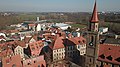
 Fürth, Kirchturm St. Martin (02).jpg 4,000 × 2,250; 3.53 MB
-
 Fürth, Kirchturm St. Martin.jpg 4,000 × 2,250; 3.6 MB
-
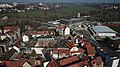
 Fürth.jpg 4,000 × 2,250; 4.08 MB
-
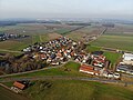
 Greimersdorf (Cadolzburg) Luftaufnahme (2020).jpg 4,056 × 3,040; 5.92 MB
-
 Luftbild Kloster Langenzenn.jpg 950 × 602; 909 KB
-
 Schwadermühle (Cadolzburg) Luftaufnahme (2020).jpg 4,056 × 3,040; 6.58 MB
-
 Seckendorf (Cadolzburg) Luftaufnahme (2020).jpg 4,056 × 3,040; 5.79 MB
-
 Seukendorf (Cadolzburg) Luftaufnahme (2020).jpg 4,056 × 3,040; 6.59 MB
-
 Spargelfeld bei Rothenberg (Obermichelbach) Luftaufnahme (2020).jpg 4,056 × 3,040; 6.06 MB
-
 St Michael Fürth Dach.jpg 4,000 × 2,250; 3.67 MB
-
 Untermichelbach Luftaufnahme (2020).jpg 4,056 × 3,040; 5.31 MB
-
 Veitsbronn Panorama Luftaufnahme (2020).jpg 5,942 × 2,451; 7.32 MB

.jpg)
.jpg)
.jpg)


.jpg)


_Luftaufnahme_(2020).jpg)

_Luftaufnahme_(2020).jpg)
_Luftaufnahme_(2020).jpg)
_Luftaufnahme_(2020).jpg)
_Luftaufnahme_(2020).jpg)

.jpg)
.jpg)