Category:Aerial photographs of Landkreis Kulmbach
Urban districts (cities): Amberg · Ansbach · Aschaffenburg · Augsburg · Bamberg · Bayreuth · Coburg · Erlangen · Fürth · Hof · Kaufbeuren · Kempten · Landshut · Memmingen · Munich · Nuremberg · Passau · Regensburg · Rosenheim · Schwabach · Straubing · Weiden in der Oberpfalz · Würzburg
Subcategories
This category has only the following subcategory.
Media in category "Aerial photographs of Landkreis Kulmbach"
The following 15 files are in this category, out of 15 total.
-
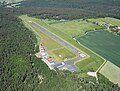 Aerial image of the Kulmbach airfield (view from the east).jpg 4,200 × 3,200; 5.83 MB
-
 Aerial image of the Kulmbach airfield.jpg 4,800 × 3,200; 3.59 MB
-
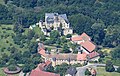 Aerial image of the Wernstein Castle (Upper Franconia).jpg 4,400 × 2,800; 5.43 MB
-
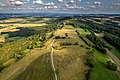
 Alladorf Luftbild-20210718-RM-165350.jpg 5,139 × 3,640; 10.12 MB
-
 Alladorf Luftbild-20210718-RM-165456.jpg 4,780 × 3,640; 10.02 MB
-
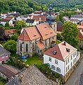
 Alladorf St.Nikolaus Luftbild-20210718-RM-164931.jpg 4,571 × 3,640; 10.36 MB
-
 Alladorf St.Nikolaus Luftbild-20210718-RM-164949.jpg 4,838 × 3,640; 10.16 MB
-
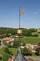 Alladorf St.Nikolaus Turmspitze-20210718-RM-165104.jpg 2,425 × 3,640; 4.04 MB
-
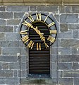 Alladorf St.Nikolaus Turmuhr-20210718-RM-165246.jpg 2,391 × 2,561; 2.87 MB
-
 Burg Zwernitz Luftbild.jpg 1,600 × 988; 1.64 MB
-
 Görauer Anger Luftbild-20210821-RM-170802.jpg 5,464 × 3,640; 9.76 MB
-
 Görauer Anger Luftbild-20210821-RM-170830.jpg 5,464 × 3,640; 13.4 MB
-
 Johanneskirche Kasendorf Luftbild-20230814-RM-172617.jpg 3,524 × 3,597; 11.07 MB
-
 Magnusturm Kasendorf Luftbild-20230814-RM-172935.jpg 3,699 × 2,848; 7.9 MB
-
 Melkendorf St. Aegidius Luftbild-20230814-RM-165931.jpg 2,377 × 2,865; 4.5 MB
.jpg)

.jpg)


