Category:Aerial photographs of Landkreis Fürstenfeldbruck
Urban districts (cities): Amberg · Ansbach · Aschaffenburg · Augsburg · Bamberg · Bayreuth · Coburg · Erlangen · Fürth · Hof · Kaufbeuren · Kempten · Landshut · Memmingen · Munich · Nuremberg · Passau · Regensburg · Rosenheim · Schwabach · Straubing · Weiden in der Oberpfalz · Würzburg
Deutsch: Luftaufnahmen aus dem Landkreis Fürstenfeldbruck.
Subcategories
This category has only the following subcategory.
Media in category "Aerial photographs of Landkreis Fürstenfeldbruck"
The following 6 files are in this category, out of 6 total.
-
 A96 fahrzeiten.jpg 2,076 × 1,260; 768 KB
-
 Aerial image of Ampersee (view from the south).jpg 3,900 × 2,200; 4.63 MB
-
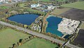
 Aerial image of Olchinger See (view from the southwest).jpg 3,600 × 2,200; 4.78 MB
-
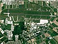
 Aerial image of the Jesenwang airfield.jpg 5,480 × 3,580; 4.45 MB
-
 Fürstenfeldbruck Airfield Aerial.jpg 913 × 684; 237 KB
-
 Luftbild Gesamtareal kleiner.jpg 1,775 × 1,181; 1.35 MB

.jpg)
.jpg)


