Category:Aerial photographs of airports in Maine
States of the United States: Alabama · Alaska · Arizona · Arkansas · California · Colorado · Connecticut · Delaware · Florida · Georgia · Hawaii · Idaho · Illinois · Indiana · Iowa · Kansas · Kentucky · Louisiana · Maine · Maryland · Massachusetts · Michigan · Minnesota · Mississippi · Missouri · Montana · Nebraska · Nevada · New Hampshire · New Jersey · New Mexico · New York · North Carolina · North Dakota · Ohio · Oklahoma · Oregon · Pennsylvania · Rhode Island · South Carolina · South Dakota · Tennessee · Texas · Utah · Vermont · Virginia · Washington · West Virginia · Wisconsin · Wyoming
Puerto Rico
Puerto Rico
English: Aerial photographs of airports in the state of Maine, United States
Media in category "Aerial photographs of airports in Maine"
The following 8 files are in this category, out of 8 total.
-
 20131003T182434Z TY12991-AugustaME.jpg 4,928 × 3,264; 5.58 MB
-
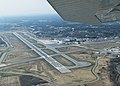
 Bangor-International-Aerial.jpg 699 × 533; 142 KB
-
 Deblois Flight Strip - USGS 16 May 1996.jpg 2,000 × 2,000; 522 KB
-
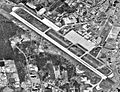
 Dow AAF Maine - 11 July 1944.jpg 698 × 432; 101 KB
-
 Dow Air Force Base - Maine.jpg 671 × 620; 208 KB
-
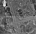
 Dow-afb-maine-may-9-1996.jpg 849 × 943; 279 KB
-
 KPWM Aerial Wiki.jpg 830 × 594; 403 KB
-
 Presque Isle Air Force Base Maine-9 May 1996.jpg 770 × 738; 144 KB


