Category:Aerial photographs of airports in Montana
States of the United States: Alabama · Alaska · Arizona · Arkansas · California · Colorado · Connecticut · Delaware · Florida · Georgia · Hawaii · Idaho · Illinois · Indiana · Iowa · Kansas · Kentucky · Louisiana · Maine · Maryland · Massachusetts · Michigan · Minnesota · Mississippi · Missouri · Montana · Nebraska · Nevada · New Hampshire · New Jersey · New Mexico · New York · North Carolina · North Dakota · Ohio · Oklahoma · Oregon · Pennsylvania · Rhode Island · South Carolina · South Dakota · Tennessee · Texas · Utah · Vermont · Virginia · Washington · West Virginia · Wisconsin · Wyoming
Puerto Rico
Puerto Rico
English: Aerial photographs of airports in the state of Montana, United States
Media in category "Aerial photographs of airports in Montana"
The following 14 files are in this category, out of 14 total.
-
 Cut Bank Municipal Airport - Montana.jpg 655 × 436; 104 KB
-
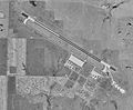
 Cut Bank Municipal Airport-MT-28Jul1995-USGS.jpg 728 × 387; 85 KB
-
 Dell Flight Strip- MT - 1 Aug 1995 - USGS.jpg 461 × 649; 95 KB
-
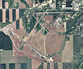
 Glasgow Air Force Base - Montana.jpg 665 × 557; 104 KB
-
 Glasgow Airport - Montana.jpg 672 × 784; 70 KB
-
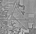 Glasgow Airport-MT-11Aug1996-USGS.jpg 507 × 475; 66 KB
-
 Glasgowafb-11aug1996.jpg 714 × 588; 84 KB
-
 Great falls final approach.JPG 2,560 × 1,920; 1.84 MB
-
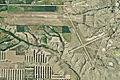
 Great Falls International Airport - Montana.jpg 739 × 758; 144 KB
-
 Greatfallsaab-1944.jpg 600 × 427; 108 KB
-
 Helena Regional Airport - Montana.jpg 772 × 577; 132 KB
-
 Lewistown Municipal Airport - Montana.jpg 616 × 508; 104 KB
-
 Lewistown Municipal Airport-MT-28Aug1997-USGS.jpg 1,247 × 807; 248 KB
-
 Malmstrom Air Force Base - MT - 8 Jul 1995.jpg 458 × 516; 69 KB


