Category:Creeks in California
States of the United States: Alabama · Alaska · Arizona · Arkansas · California · Colorado · Delaware · Florida · Georgia · Idaho · Illinois · Indiana · Iowa · Kansas · Kentucky · Louisiana · Maine · Maryland · Minnesota · Mississippi · Missouri · Montana · Nevada · New Jersey · New York · North Carolina · Ohio · Oklahoma · Oregon · Pennsylvania · South Dakota · Tennessee · Texas · Utah · Virginia · Washington · West Virginia · Wisconsin · Wyoming
- See also: Category: Streams in California.
Subcategories
This category has the following 67 subcategories, out of 67 total.
A
- Arroyo Burro Creek (3 F)
B
- Baxter Creek (5 F)
- Bear Creek (Placer County) (1 F)
- Big Chico Creek (2 F)
- Bolam Creek (3 F)
- Bull Creek (Los Angeles) (6 F)
C
- Calabazas Creek (4 F)
- Centinela Creek (6 F)
- Chollas Creek (7 F)
- Codornices Creek (4 F)
- Coyote Creek (Marin County) (1 F)
D
E
H
- Holy Jim Creek (1 F)
I
K
- Kaiser Creek (6 F)
L
- Los Alamitos Creek (20 F)
M
- Martis Creek Lake (26 F)
O
P
- Pinole Creek (2 F)
- Piru Creek (4 F)
S
- San Carpóforo Creek (4 F)
- San Francisquito Creek (20 F)
- Sespe Creek (14 F)
T
- Temescal Creek (10 F)
- Tinnemaha Creek (2 F)
- Tunitas Creek (3 F)
V
- Van Buren Creek (1 F)
- Verdugo Wash (6 F)
- Volcano Creek (9 F)
W
- Ward Creek (Lake Tahoe) (3 F)
Y
Z
- Zim Zim Creek (1 F)
Media in category "Creeks in California"
The following 200 files are in this category, out of 253 total.
(previous page) (next page)-
 'Dry Arroyo, California' by D. Howard Hitchcock, 1910.jpg 2,528 × 1,924; 1.26 MB
-
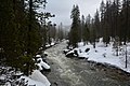 170209-FS-Sierra-AO-003 (32044140344).jpg 2,048 × 1,366; 461 KB
-
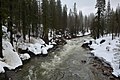 170209-FS-Sierra-AO-004 (32044140494).jpg 2,048 × 1,366; 479 KB
-
 A creek in Burlingame.jpeg 1,920 × 2,560; 924 KB
-
 Aerial-Douglas-ArroyoBurro.jpg 940 × 768; 201 KB
-
 Alder Creek beaver pond.jpg 3,604 × 2,428; 3.06 MB
-
 Alder Creek below Fjord Road.jpg 4,032 × 3,024; 5.28 MB
-
 Alder Creek footbridge pano.jpg 4,932 × 1,615; 6.6 MB
-
 Alder Creek frozen at Prosser Creek Reservoir.jpg 3,024 × 3,718; 4.01 MB
-
 Alder Creek mouth pano.jpg 3,410 × 613; 1.3 MB
-
 Alder Creek mouth.jpg 3,632 × 1,249; 1.3 MB
-
 Aptos Creek - panoramio.jpg 3,264 × 2,448; 2.54 MB
-
 Aptos Creek birds.jpg 3,024 × 4,032; 3.9 MB
-
 Aqua Caliente Reservation - NARA - 298622.jpg 3,000 × 1,776; 1.43 MB
-
 ArroyoLasPositas.jpg 4,592 × 3,448; 7.32 MB
-
 ArroyoSeco1.jpg 4,592 × 3,448; 8.12 MB
-
 Atascadero Creek (25359535254).jpg 3,156 × 2,169; 2.89 MB
-
 Ballona-Centinela.jpg 2,048 × 1,010; 709 KB
-
 Bear Creek at Mountain Home Rd.jpg 2,160 × 3,310; 3.36 MB
-
 Bear Creek below Mountain Home Road.jpg 3,840 × 2,160; 3.4 MB
-
 Bear Creek Joins San Francisquito Creek July 2011.jpg 2,593 × 2,592; 6.21 MB
-
 Beaver dams upper Los Gatos Creek 2009.jpg 681 × 1,024; 325 KB
-
 Beaver Lodge on Tulucay Creek, Napa River tributary May 2014.jpg 3,648 × 2,736; 7.61 MB
-
 Bell Creek.jpg 3,648 × 2,736; 2.14 MB
-
 Below the Falls in the Arroyo Seco, near Pasadena, ca.1900 (CHS-4664).jpg 3,982 × 5,100; 1.38 MB
-
 Berryessa Creek Park Bridge.jpg 4,928 × 3,264; 9.23 MB
-
 Bierstadt Albert Campfire Site Yosemite.jpg 805 × 1,001; 331 KB
-
 BigChicoCreek BidwellPark.jpg 800 × 604; 96 KB
-
 Bluff Creek and Playa Vista.jpg 1,600 × 1,189; 846 KB
-
 Bluff Creek, Playa Vista.jpg 3,024 × 4,032; 7.05 MB
-
 Branciforte Creek Bridge.jpg 3,072 × 4,096; 3.48 MB
-
 Bridge over Los Gatos Creek - panoramio.jpg 4,270 × 2,847; 3.49 MB
-
 Bridge Scream.jpg 960 × 1,280; 271 KB
-
 Bull creek north from victory.jpg 2,400 × 1,715; 1,012 KB
-
 Bulletin of the Bureau of Fisheries (1905) (14763766984).jpg 1,840 × 1,356; 361 KB
-

-

-

-
-

-

-

-
 CacheCreek.jpg 1,028 × 736; 256 KB
-
 Calera Creek California 2006 01.jpg 2,196 × 1,428; 2.97 MB
-
 California fish and game (19892243323).jpg 2,085 × 3,249; 250 KB
-
 CALIFORNIA--BIG CREEK - NARA - 542594.jpg 2,006 × 3,000; 5.16 MB
-
 Callahan Creek.jpg 3,024 × 4,032; 6.45 MB
-
 Canyon Creek (3622580349).jpg 853 × 1,280; 389 KB
-
 Carbonara Ck meet B40.JPG 2,592 × 1,936; 1.89 MB
-
 Cerrito Creek at Ohlone Greenway.jpg 4,592 × 3,448; 7.65 MB
-
 Chino Creek downstream from Central Avenue.jpeg 320 × 240; 28 KB
-
 Chinook salmon on Los Gatos Creek 1996-11-09.jpg 676 × 498; 499 KB
-
 Clear Creek, Siskiyou Wilderness.jpg 1,920 × 1,244; 2.53 MB
-
 Cold Creek (Donner Creek tributary) pano.jpg 5,776 × 1,651; 6.58 MB
-
 Cold Creek (Donner Creek tributary).jpg 3,024 × 4,032; 3.84 MB
-
 ComptonCreekFromWallStreet20120929.jpg 1,500 × 1,124; 954 KB
-

-

-

-

-
 Cow Creek Shasta County California.jpg 1,750 × 1,219; 644 KB
-

-

-
-

-
 Creek (140443105).jpeg 1,365 × 2,048; 1.57 MB
-
 Creek (15919832738).jpg 2,448 × 3,264; 1.21 MB
-
 Creek (8045351649).jpg 3,000 × 4,000; 4.32 MB
-
 Creek Cleanup.jpg 6,000 × 4,000; 6.92 MB
-
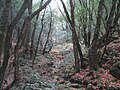
 Creek in old growth redwood forest.jpg 2,448 × 3,264; 3.7 MB
-
 CrkCleanup.jpg 579 × 251; 72 KB
-
 Deer Creek - panoramio - srsmedly.jpg 1,600 × 1,200; 426 KB
-
 Deer Creek - panoramio.jpg 1,600 × 1,200; 426 KB
-
 Deer Creek long shot (18471487494).jpg 577 × 768; 593 KB
-
 Defense.gov photo essay 090616-M-0268M-047.jpg 3,492 × 2,328; 7.39 MB
-
 DGP ToneMap (10316545706).jpg 4,296 × 2,844; 13.8 MB
-
 Donner Creek above Donner Lake.jpg 3,240 × 1,656; 3.98 MB
-
 Donner Creek Cold Creek confluence.jpg 5,864 × 1,650; 6.86 MB
-
 Donner Creek entering Donner Lake.jpg 4,076 × 1,638; 3.52 MB
-
 Donner Creek leaving Donner Lake.jpg 4,032 × 3,024; 3.75 MB
-
 DoolanCanyon.jpg 4,592 × 3,448; 7.9 MB
-
 Douglas-Creek-near-Stanislaus-National-Forest,-California.jpg 4,608 × 3,456; 5.04 MB
-
 Draft Clear Creek management plan and environmental assessment (1985) (20996108115).jpg 3,760 × 2,600; 2.12 MB
-
 Dry Creek exiting under Mountain Home Road Woodside.jpg 2,160 × 3,120; 2.59 MB
-
 Elfin Forest.jpg 3,008 × 2,000; 1.68 MB
-
 Erosion from loss of riparian vegetation Hidden Villa 2010.jpg 2,592 × 1,936; 2.62 MB
-
 Extended view of Little Cholame Creek.jpg 3,264 × 1,836; 3.35 MB
-
 Fall Leaves (9958030844).jpg 2,967 × 2,250; 7.4 MB
-
 Fallen Redwood in Adobe Creek.jpg 1,280 × 960; 911 KB
-
 FEMA - 43252 - Damaged Road in California.jpg 2,400 × 3,600; 7.32 MB
-
 Fish Ladder Los Trancos Creek 2011.jpg 1,936 × 2,592; 5.65 MB
-
 Flow of the Heart.jpg 6,000 × 4,000; 6.38 MB
-

-
 FMIB 39575 Whitney Creek as it enters Crabtree Meadow.jpeg 571 × 789; 128 KB
-
 Garrapata Creek California 2006 01.jpg 2,206 × 1,380; 1.97 MB
-
 Garrapata Creek California 2006 02.jpg 2,256 × 1,496; 2.87 MB
-
 Garrapata Creek California 2006 03.jpg 2,256 × 1,496; 2.75 MB
-
 Garrapata Creek California 2006 04.jpg 1,388 × 2,097; 919 KB
-
 General Creek at Sugar Pine Point State Park.jpg 3,008 × 2,000; 5.21 MB
-
 Glen Echo Creek culvert Oakland.jpg 2,016 × 1,512; 1.1 MB
-
 Glen Echo Creek in park.jpg 2,016 × 1,512; 1.71 MB
-
 Glen Echo Creek Oakland.jpg 1,442 × 1,972; 1.32 MB
-
 Glen Echo Creek Park culvert.jpg 2,016 × 1,512; 1.35 MB
-
 Goleta Beach (2013) 18.JPG 4,512 × 3,000; 5.65 MB
-
 Google Gate Bridge.jpg 3,264 × 2,448; 3.41 MB
-
 Hale Creek at Marilyn Drive Mountain View.jpg 1,512 × 2,216; 1.03 MB
-
 Hale creek los altos.jpg 4,608 × 3,456; 2.63 MB
-
 Hale Creek outflow of Neary Quarry.jpg 1,160 × 1,528; 677 KB
-
 Hare Canyon Creek (8613081678).jpg 4,000 × 3,000; 4.53 MB
-
 Hare Canyon Creek (8613083124).jpg 3,000 × 4,000; 4.14 MB
-
 Hayfork Creek.jpg 494 × 327; 63 KB
-
 Hidden Villa bridge 2010.jpg 720 × 1,280; 837 KB
-
 Honcut Creek floodplain, North side of Honcut Creek, Aug 1952 (26790383721).jpg 1,568 × 1,045; 1.09 MB
-
 Ishi lowermillcreek.jpg 133 × 100; 5 KB
-

-
 Kaiser Creek in April.png 2,326 × 1,728; 9.57 MB
-
 Kingsmen creek cal lutheran.png 1,140 × 896; 1.54 MB
-
 Kit Carson Creek.jpg 3,024 × 4,032; 4.88 MB
-
 La Ballona KAP 7.jpg 3,072 × 2,048; 2.35 MB
-
-

-
 Lafayette Creek in Downtown Lafayette.png 1,694 × 1,728; 7.35 MB
-
 Lagunitas Creek in Samuel P. Taylor State Park.jpg 2,048 × 1,536; 2.57 MB
-
 Lagunitas Creek.jpg 3,965 × 3,160; 4.63 MB
-
 Lake Nacimiento, Ca.jpg 3,264 × 2,448; 3.75 MB
-
 Lassen Peak looking south.jpg 1,200 × 1,600; 399 KB
-
 Leidy 2009 Smith Creek in July 2009 upstream from Mt. Hamilton Road bridge crossing.JPG 2,448 × 3,264; 3.32 MB
-
 Little Chico Creek.jpg 330 × 247; 138 KB
-
 Lower Silver Creek at Babb Creek confluence, Silver Ave.jpg 4,032 × 3,024; 6.11 MB
-
 Lower Silver Creek at Cunningham Ave.jpg 4,032 × 3,024; 3.89 MB
-
 Lower Silver Creek draining from Lake Cunningham Regional Park.jpg 4,032 × 3,024; 4.78 MB
-
 The-rindge.jpg 2,560 × 1,920; 1.04 MB
-
 Malibu Canyon.JPG 3,264 × 2,448; 3.42 MB
-
 Malibu Creek dry bed.jpg 1,600 × 1,200; 1.15 MB
-
 Mammoth Lakes (November 2009) 01.JPG 2,592 × 1,944; 1.36 MB
-

-

-
 Marin Creek.jpg 2,560 × 1,920; 3.22 MB
-
 Marshall Creek, Ben Lomond, CA.jpg 2,304 × 3,072; 1.61 MB
-
 Martis Creek Lake and Dam summer.jpg 1,500 × 987; 518 KB
-
 McArthur-Burney Falls Memorial SP Burney Creek.jpg 1,293 × 1,416; 657 KB
-
 Metrolink Trestles Beach.jpg 4,384 × 3,288; 7.35 MB
-
 Miguelita Creek from Alum Rock Road.jpg 3,024 × 4,032; 5.89 MB
-
 Miguelita Creek goes under Fairway Drive.jpg 4,032 × 3,024; 6.24 MB
-
 Miguelita or Lower Silver Creek at 101.jpg 4,032 × 3,024; 4.42 MB
-
 Miguelita or Lower Silver Creek confluence with Coyote Creek.jpg 4,032 × 3,024; 5.49 MB
-
 MILL CREEK ENTRANCE - NARA - 542537.jpg 2,030 × 3,000; 3.79 MB
-
 Mill Creek Visalia.jpg 221 × 288; 47 KB
-
 Miller Creek 3563.jpg 1,704 × 1,536; 1.89 MB
-
 Morses Gulch 3431.JPG 2,048 × 1,536; 768 KB
-
 Mouth of Coyote Creek.jpg 4,000 × 3,000; 3.49 MB
-
 Near Pyramid Reservoir, CA, View S, Stream Course, 2011 - panoramio.jpg 4,000 × 3,000; 4.54 MB
-
 Neary Quarry pano.jpg 3,225 × 905; 2.1 MB
-
 Neary Quarry.jpg 2,055 × 1,305; 1.73 MB
-

-
 Panoche Creek Abstract (21842762793).jpg 2,760 × 4,140; 1.3 MB
-
 Panoche Creek Abstract (22276237908).jpg 3,784 × 2,523; 1.09 MB
-
 Panoche Creek Abstract (22437794726).jpg 2,223 × 1,482; 617 KB
-
 Panoche Creek Abstract (22437800786).jpg 4,140 × 2,760; 1.11 MB
-
 Panoche Creek Abstract (22437811106).jpg 4,140 × 2,760; 2.21 MB
-
 Panoche Creek Abstract (22463796905).jpg 3,345 × 2,230; 1.5 MB
-
 Panoche Creek Abstract (22463937675).jpg 2,760 × 4,140; 1.23 MB
-
 Panoche Creek Abstract (22474763471).jpg 2,929 × 1,953; 836 KB
-
 Panoche Creek Context (22277101999).jpg 4,912 × 2,760; 2.15 MB
-
 Gasquet, California - Patrick Creek 05.jpg 4,288 × 2,848; 6.16 MB
-
 Permanente Creek bridge, Mountain View.jpg 3,264 × 2,448; 3.85 MB
-
 Permanente Creek Diversion Channel fish barrier at confluence with Stevens Creek 2013.JPG 1,892 × 2,560; 3.35 MB
-
 Permanente Creek in Mountain View.jpg 3,264 × 2,448; 4.21 MB
-
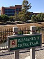 Permanente Creek Trail sign and Google building.jpg 2,448 × 3,264; 3.33 MB
-
 Permanente Creek Trail sign.jpg 3,264 × 2,448; 3.97 MB
-
 Permanente Creek weir.jpg 1,920 × 2,560; 897 KB
-
 Permanente Creek.jpg 2,560 × 1,920; 926 KB
-
 Pescadero Watershed 1 (8057661654).jpg 4,288 × 2,848; 5.86 MB
-
 Peters Creek California.jpg 1,600 × 1,200; 877 KB
-
 Pfeiffer-Redwood Creek - Stierch 2.jpg 2,848 × 4,272; 7.68 MB
-
 Pfsf Ldac opening.jpg 1,280 × 960; 284 KB
-
 Pismo Beach Creek taken at Addie Vacation Townhomes 10x72.jpg 720 × 540; 374 KB
-
 POLLUTED CREEK - NARA - 542582.jpg 2,010 × 3,000; 5.27 MB
-
 Prairie Creek Redwoods - Waterfall on Rhododendron Trail.jpg 1,728 × 2,304; 513 KB
-
 PrairieCreekFlagging.png 1,536 × 2,048; 5.68 MB
-
 PrairieCreekLongShot.jpg 1,360 × 2,048; 2.13 MB
-
 PrairieCreekRedwood.png 1,536 × 2,048; 6.32 MB
-
 PrairieCreekRiverBend.jpg 3,072 × 2,048; 3.74 MB
-
 PrairieCreekUnderstory.png 1,536 × 2,048; 6.62 MB
-
 Prefumo Creek (summer).jpg 4,096 × 3,072; 6.94 MB
-
 Prosser Creek Dam from reservoir south shore.jpg 4,032 × 2,137; 2.71 MB
-
 Prosser Creek Dam main spillway.jpg 3,024 × 4,032; 3.88 MB
-
 Prosser Creek from dam pano.jpg 3,348 × 1,387; 2.75 MB
-
 Prosser Creek from dam.jpg 3,366 × 2,268; 1.37 MB
-
 Prosser Creek pano below dam.jpg 3,993 × 1,648; 4.11 MB
-
 Prosser Creek Reservoir from dam pano.jpg 5,080 × 1,428; 3.31 MB
-
 Prosser Creek Reservoir from dam with boat.jpg 4,032 × 3,024; 2.11 MB
-
 Purisima Creek above O'Keefe Lane with water & alders Aug. 29, 2010.jpg 1,536 × 2,048; 1.87 MB
-
 Rancheria Creek - panoramio.jpg 2,272 × 1,704; 2.26 MB
-
 Rancheria creek.jpg 683 × 1,024; 707 KB
-
 Rattlesnake creek.jpg 765 × 507; 152 KB
-

-
 Rock Creek at East Fork Campground. - panoramio.jpg 1,037 × 1,565; 1.64 MB
-
 Rock Search.jpg 6,000 × 4,000; 6.72 MB
-
 Running North by burnintree.jpg 1,509 × 892; 1.02 MB

.jpg)
.jpg)


.jpg)


.jpg)


_(14763766984).jpg)
_(20453883591).jpg)


.jpg)


.jpg)


.jpg)


_falls_These_are_about_250_feet_above_the_first_falls_The_second_falls_is_50_feet.jpeg)
.jpeg)
.jpg)
.jpg)


.jpg)

.jpg)


.jpg)


_18.JPG)


.jpg)
.jpg)


.jpg)


_01.JPG)


.jpg)
.jpg)
.jpg)
.jpg)
.jpg)
.jpg)
.jpg)
.jpg)
.jpg)
.jpg)


.jpg)


.jpg)


_pano.jpg)
_(20996108115).jpg)