Category:Maps of Chippewa County, Michigan
Counties of Michigan: Alcona · Alger · Allegan · Alpena · Antrim · Arenac · Baraga · Barry · Bay · Benzie · Berrien · Branch · Calhoun · Cass · Charlevoix · Cheboygan · Chippewa · Clare · Clinton · Crawford · Delta · Dickinson · Eaton · Emmet · Genesee · Gladwin · Gogebic · Grand Traverse · Gratiot · Hillsdale · Houghton · Huron · Ingham · Ionia · Iosco · Iron · Isabella · Jackson · Kalamazoo · Kalkaska · Kent · Keweenaw · Lake · Lapeer · Leelanau · Lenawee · Livingston · Luce · Mackinac · Macomb · Manistee · Marquette · Mason · Mecosta · Menominee · Midland · Missaukee · Monroe · Montcalm · Montmorency · Muskegon · Newaygo · Oakland · Oceana · Ogemaw · Ontonagon · Osceola · Oscoda · Otsego · Ottawa · Presque Isle · Roscommon · Saginaw · Sanilac · Schoolcraft · Shiawassee · St. Clair · St. Joseph · Tuscola · Van Buren · Washtenaw · Wayne · Wexford
Wikimedia category | |||||
| Upload media | |||||
| Instance of | |||||
|---|---|---|---|---|---|
| Category combines topics | |||||
| Chippewa County | |||||
county in Michigan, United States  Chippewa County Courthouse, Sault Ste. Marie  | |||||
| Instance of | |||||
| Named after | |||||
| Location | Michigan | ||||
| Located in or next to body of water | |||||
| Capital | |||||
| Inception |
| ||||
| Population |
| ||||
| Area |
| ||||
| Different from | |||||
| official website | |||||
 | |||||
Subcategories
This category has the following 2 subcategories, out of 2 total.
M
O
Media in category "Maps of Chippewa County, Michigan"
The following 26 files are in this category, out of 26 total.
-
 Bruce Township (Chippewa County), Michigan location.png 2,664 × 2,520; 308 KB
-
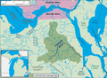 Charlotte River Michigan map.png 2,850 × 2,100; 307 KB
-
-
 Chippewa county, MI 1904.png 574 × 476; 99 KB
-
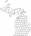
 Chippewa County, MI census map.png 2,664 × 2,520; 439 KB
-
 Chippewa Township (Chippewa County), MI location.png 2,664 × 2,520; 308 KB
-
 ChippewaCountyLabels.png 1,000 × 1,000; 184 KB
-
 Detour Township, Michigan.png 2,664 × 2,520; 307 KB
-
 Detour Village location.png 2,664 × 2,520; 307 KB
-
 Drummond Township, Michigan.png 2,664 × 2,520; 308 KB
-
 Hulbert Township, Michigan.png 2,664 × 2,520; 308 KB
-
 Kinross Charter Township, Michigan.png 2,664 × 2,520; 306 KB
-
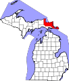 Map of Michigan highlighting Chippewa County.svg 6,256 × 7,325; 205 KB
-
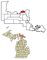
 MIMap-doton-Barbeau.PNG 261 × 300; 13 KB
-
 MIMap-doton-Paradise.PNG 261 × 300; 13 KB
-
 Pickford Township, Michigan.png 2,664 × 2,520; 307 KB
-
 Raber Township, Michigan.png 2,664 × 2,520; 307 KB
-
 Rudyard Township, Michigan.png 2,664 × 2,520; 307 KB
-
 Sault Ste. Marie, Michigan (map).png 2,664 × 2,520; 307 KB
-
 Soo Township, Michigan.png 2,664 × 2,520; 306 KB
-
 Sugar Island Township, Michigan.png 2,664 × 2,520; 307 KB
-
 Superior Township (Chippewa County), Michigan.png 2,664 × 2,520; 307 KB
-
 Trout Lake Township, Michigan.png 2,664 × 2,520; 308 KB
-
 Whitefish Point Map (1).jpg 2,088 × 1,486; 145 KB
-
 Whitefish Point Map.jpg 2,088 × 1,486; 138 KB
-
 Whitefish Township, Michigan.png 2,664 × 2,520; 308 KB
,_Michigan_location.png)


,_MI_location.png)


.png)


,_Michigan.png)

.jpg)

