Category:Maps of Keweenaw County, Michigan
Counties of Michigan: Alcona · Alger · Allegan · Alpena · Antrim · Arenac · Baraga · Barry · Bay · Benzie · Berrien · Branch · Calhoun · Cass · Charlevoix · Cheboygan · Chippewa · Clare · Clinton · Crawford · Delta · Dickinson · Eaton · Emmet · Genesee · Gladwin · Gogebic · Grand Traverse · Gratiot · Hillsdale · Houghton · Huron · Ingham · Ionia · Iosco · Iron · Isabella · Jackson · Kalamazoo · Kalkaska · Kent · Keweenaw · Lake · Lapeer · Leelanau · Lenawee · Livingston · Luce · Mackinac · Macomb · Manistee · Marquette · Mason · Mecosta · Menominee · Midland · Missaukee · Monroe · Montcalm · Montmorency · Muskegon · Newaygo · Oakland · Oceana · Ogemaw · Ontonagon · Osceola · Oscoda · Otsego · Ottawa · Presque Isle · Roscommon · Saginaw · Sanilac · Schoolcraft · Shiawassee · St. Clair · St. Joseph · Tuscola · Van Buren · Washtenaw · Wayne · Wexford
Wikimedia category | |||||
| Upload media | |||||
| Instance of | |||||
|---|---|---|---|---|---|
| Category combines topics | |||||
| Keweenaw County | |||||
county in the Upper Peninsula of Michigan, United States   | |||||
| Instance of | |||||
| Location | Michigan | ||||
| Located in or next to body of water | |||||
| Capital | |||||
| Inception |
| ||||
| Population |
| ||||
| Area |
| ||||
| official website | |||||
 | |||||
Subcategories
This category has only the following subcategory.
O
Media in category "Maps of Keweenaw County, Michigan"
The following 21 files are in this category, out of 21 total.
-
 Copper Harbor, MI location.png 4,400 × 2,296; 364 KB
-
 Eagle Harbor Township, Michigan3.png 4,400 × 2,296; 362 KB
-
 Eagle Harbor, MI location.png 4,400 × 2,296; 364 KB
-
 Eagle River, MI location.png 4,400 × 2,296; 364 KB
-
 Grant Township (Keweenaw), Michigan3.png 4,400 × 2,296; 363 KB
-
 Houghton MSA.png 460 × 442; 5 KB
-
 Houghton Township, Michigan3.png 4,400 × 2,296; 363 KB
-
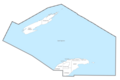
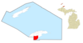
 Isle Royale highlighted.png 1,000 × 1,126; 243 KB
-
 IsleRoyaleMap.jpg 2,451 × 1,095; 373 KB
-
 MinongMineLocation.JPG 1,151 × 789; 145 KB
-

-
 Keweenaw County, MI census map.png 3,424 × 2,272; 319 KB
-
 Keweenaw County, MI census map2.png 3,424 × 2,272; 332 KB
-
 KeweenawPeninsula.svg 446 × 365; 74 KB
-
 M-6 in 1936.jpg 647 × 422; 117 KB
-
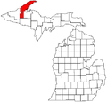
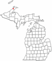
 Map of Michigan highlighting Keweenaw County.svg 962 × 1,127; 138 KB
-
 Michigan Senate District 38 (2010).png 3,200 × 3,450; 703 KB
-
 MichiganCopperIsland.svg 446 × 365; 73 KB
-
 MIMap-doton-Ahmeek.PNG 261 × 300; 13 KB
-
 Sherman Township (Keewenaw), Michigan3.png 4,400 × 2,296; 364 KB
-
 USGS Professional Paper 144, Plate 3.jpg 5,726 × 3,203; 803 KB


,_Michigan3.png)


.png)


,_Michigan3.png)
