Category:Maps of Great Sand Dunes National Park and Preserve
United States national parks: Acadia · American Samoa · Arches · Badlands · Big Bend · Biscayne · Black Canyon of the Gunnison · Bryce Canyon · Canyonlands · Capitol Reef · Carlsbad Caverns · Channel Islands · Congaree · Crater Lake · Cuyahoga Valley · Death Valley · Denali · Dry Tortugas · Everglades · Gateway Arch · Gates of the Arctic · Glacier · Glacier Bay · Grand Canyon · Grand Teton · Great Basin · Great Smoky Mountains · Guadalupe Mountains · Haleakalā · Hawaii Volcanoes · Hot Springs · Indiana Dunes · Isle Royale · Joshua Tree · Kenai Fjords · Kings Canyon · Kobuk Valley · Lake Clark · Lassen Volcanic · Mammoth Cave · Mesa Verde · Mount Rainier · North Cascades · Olympic · Petrified Forest · Pinnacles · Redwood · Rocky Mountain · Saguaro · Sequoia · Shenandoah · Theodore Roosevelt · Virgin Islands · Voyageurs · White Sands · Wind Cave · Wrangell-St. Elias · Yellowstone · Yosemite · Zion
English: Maps of Great Sand Dunes National Park and Preserve
| NO WIKIDATA ID FOUND! Search for Maps of Great Sand Dunes National Park and Preserve on Wikidata | |
| Upload media |
Subcategories
This category has the following 2 subcategories, out of 2 total.
Media in category "Maps of Great Sand Dunes National Park and Preserve"
The following 8 files are in this category, out of 8 total.
-
 LocMap Great Sand Dunes National Park.png 280 × 183; 31 KB
-
 NPS great-sand-dunes-backcountry-map.jpg 1,405 × 1,614; 388 KB
-
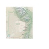
 NPS great-sand-dunes-map.jpg 3,291 × 3,912; 2.01 MB
-
 NPS great-sand-dunes-map.pdf 2,466 × 2,933; 18.48 MB
-
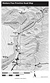 NPS great-sand-dunes-medano-pass-map.jpg 1,360 × 2,240; 368 KB
-
 NPS great-sand-dunes-pinyon-flats-campground-map.gif 1,306 × 1,344; 347 KB
-
 NPS great-sand-dunes-regional-map.jpg 578 × 441; 50 KB
-
 NPS great-sand-dunes-regional-map.pdf 345 × 264; 665 KB


