Category:Maps of Indiana Dunes National Park
United States national parks: Acadia · American Samoa · Arches · Badlands · Big Bend · Biscayne · Black Canyon of the Gunnison · Bryce Canyon · Canyonlands · Capitol Reef · Carlsbad Caverns · Channel Islands · Congaree · Crater Lake · Cuyahoga Valley · Death Valley · Denali · Dry Tortugas · Everglades · Gateway Arch · Gates of the Arctic · Glacier · Glacier Bay · Grand Canyon · Grand Teton · Great Basin · Great Smoky Mountains · Guadalupe Mountains · Haleakalā · Hawaii Volcanoes · Hot Springs · Indiana Dunes · Isle Royale · Joshua Tree · Kenai Fjords · Kings Canyon · Kobuk Valley · Lake Clark · Lassen Volcanic · Mammoth Cave · Mesa Verde · Mount Rainier · North Cascades · Olympic · Petrified Forest · Pinnacles · Redwood · Rocky Mountain · Saguaro · Sequoia · Shenandoah · Theodore Roosevelt · Virgin Islands · Voyageurs · White Sands · Wind Cave · Wrangell-St. Elias · Yellowstone · Yosemite · Zion
Wikimedia category | |||||
| Upload media | |||||
| Instance of | |||||
|---|---|---|---|---|---|
| Category combines topics | |||||
| Indiana Dunes National Park | |||||
United States National Park in Indiana  | |||||
| Instance of | |||||
| Location |
| ||||
| Located in or next to body of water | |||||
| Visitor center |
| ||||
| Operator | |||||
| IUCN protected areas category | |||||
| Inception |
| ||||
| Area |
| ||||
| Visitors per year |
| ||||
| official website | |||||
 | |||||
Subcategories
This category has only the following subcategory.
Media in category "Maps of Indiana Dunes National Park"
The following 13 files are in this category, out of 13 total.
-
 Indana Dunes National Lakeshore NPS map.jpg 2,400 × 1,066; 223 KB
-
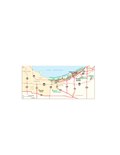
 Indiana Dunes NL parkmap east.jpg 2,000 × 1,400; 154 KB
-
 Indiana Dunes parkmap west.jpg 2,000 × 1,400; 167 KB
-
 Miller Woods Trail Map.JPG 1,134 × 868; 131 KB
-
 NPS indiana-dunes-dune-ridge-trail-map.jpg 723 × 1,311; 148 KB
-
 NPS indiana-dunes-dunewood-campground-map.gif 2,022 × 789; 202 KB
-
 NPS indiana-dunes-great-marsh-trail-map.jpg 740 × 1,324; 79 KB
-
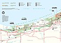
 NPS indiana-dunes-map.jpg 3,331 × 2,034; 672 KB
-
 NPS indiana-dunes-map.pdf 3,329 × 2,033; 1.84 MB
-
 NPS indiana-dunes-miller-woods-trail-map.jpg 1,396 × 886; 182 KB
-
 NPS indiana-dunes-portage-lakefront-riverwalk-trail-map.jpg 873 × 1,578; 89 KB
-
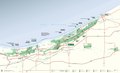
 NPS indiana-dunes-regional-map.jpg 973 × 442; 86 KB
-
 NPS indiana-dunes-regional-map.pdf 770 × 350; 481 KB


