Category:Maps of Isle Royale National Park
United States national parks: Acadia · American Samoa · Arches · Badlands · Big Bend · Biscayne · Black Canyon of the Gunnison · Bryce Canyon · Canyonlands · Capitol Reef · Carlsbad Caverns · Channel Islands · Congaree · Crater Lake · Cuyahoga Valley · Death Valley · Denali · Dry Tortugas · Everglades · Gateway Arch · Gates of the Arctic · Glacier · Glacier Bay · Grand Canyon · Grand Teton · Great Basin · Great Smoky Mountains · Guadalupe Mountains · Haleakalā · Hawaii Volcanoes · Hot Springs · Indiana Dunes · Isle Royale · Joshua Tree · Kenai Fjords · Kings Canyon · Kobuk Valley · Lake Clark · Lassen Volcanic · Mammoth Cave · Mesa Verde · Mount Rainier · North Cascades · Olympic · Petrified Forest · Pinnacles · Redwood · Rocky Mountain · Saguaro · Sequoia · Shenandoah · Theodore Roosevelt · Virgin Islands · Voyageurs · White Sands · Wind Cave · Wrangell-St. Elias · Yellowstone · Yosemite · Zion
English: Maps of Isle Royale National Park
Wikimedia category | |||||
| Upload media | |||||
| Instance of | |||||
|---|---|---|---|---|---|
| Category combines topics | |||||
| Isle Royale National Park | |||||
United States National Park on Isle Royale in the Upper Peninsula of Michigan .jpg) The Lake Superior shore at Isle Royale .jpg) | |||||
| Instance of | |||||
| Location | Keweenaw County, Michigan | ||||
| Operator | |||||
| IUCN protected areas category | |||||
| Inception |
| ||||
| Highest point |
| ||||
| Area |
| ||||
| Visitors per year |
| ||||
| official website | |||||
 | |||||
Subcategories
This category has the following 3 subcategories, out of 3 total.
Media in category "Maps of Isle Royale National Park"
The following 20 files are in this category, out of 20 total.
-
 LocMap Isle Royale.png 280 × 183; 15 KB
-
 Isle Royale highlighted.png 1,000 × 1,126; 243 KB
-
 IsleRoyaleMap.svg 898 × 593; 361 KB
-
 An ecological survey of Isle Royale, Lake Superior (1909) (20144181154).jpg 3,750 × 2,214; 1.78 MB
-
 An ecological survey of Isle Royale, Lake Superior (1909) (20144185894).jpg 2,998 × 1,514; 1.04 MB
-
 An ecological survey of Isle Royale, Lake Superior (1909) (20578787270).jpg 4,866 × 2,546; 2.47 MB
-
 Isle Royale shipwrecks Lake Superior.jpg 1,190 × 550; 124 KB
-
 IsleRoyaleMap.jpg 2,451 × 1,095; 373 KB
-
 IsleRoyaleMap.png 1,200 × 793; 119 KB
-
 Map of Isle Royale National Park.png 3,250 × 1,448; 1.1 MB
-
 MinongMineLocation.JPG 1,151 × 789; 145 KB
-
 NPS isle-royale-dive-map.jpg 720 × 275; 117 KB
-
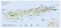
 NPS isle-royale-map.jpg 3,000 × 1,370; 607 KB
-
 NPS isle-royale-map.pdf 2,570 × 1,172; 1.63 MB
-
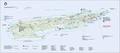
 NPS isle-royale-national-park-map.jpg 3,564 × 2,133; 875 KB
-
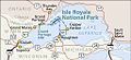 NPS isle-royale-regional-map.jpg 1,024 × 472; 111 KB
-
 NPS isle-royale-regional-map.pdf 383 × 177; 46 KB
-
 NPS isle-royale-relief-map.jpg 2,884 × 884; 212 KB
-
 NPS isle-royale-rock-harbor-map.jpg 1,100 × 1,266; 213 KB
-
 NPS isle-royale-windigo-map.jpg 1,238 × 950; 116 KB


_(20144181154).jpg)
_(20144185894).jpg)
_(20578787270).jpg)


