Category:Old county maps of England

Ceremonial counties of England: Bedfordshire · Berkshire · Buckinghamshire · Cambridgeshire · Cheshire · Cornwall · Cumbria · Derbyshire · Devon · Dorset · County Durham · East Riding of Yorkshire · East Sussex · Essex · Gloucestershire · London · Greater Manchester · Hampshire · Herefordshire · Hertfordshire · Isle of Wight · Kent · Lancashire · Leicestershire · Lincolnshire · Merseyside · Norfolk, England · North Yorkshire · Northamptonshire · Northumberland · Nottinghamshire · Oxfordshire · Rutland · Shropshire · Somerset · South Yorkshire · Staffordshire · Suffolk · Surrey · Tyne and Wear · Warwickshire · West Midlands (county) · West Sussex · West Yorkshire · Wiltshire · Worcestershire
City-counties: Bristol · City of London
Former historic counties: Cumberland · Huntingdonshire · County of London · Middlesex · North Riding of Yorkshire · Sussex · West Riding of Yorkshire · Westmorland · Yorkshire
Other former counties: Avon · Cambridgeshire and Isle of Ely · Cleveland · East Suffolk · Hereford and Worcester · Hexhamshire · Humberside · Huntingdon and Peterborough · Isle of Ely · Parts of Holland · Parts of Kesteven · Parts of Lindsey · Soke of Peterborough · West Suffolk
Subcategories
This category has the following 42 subcategories, out of 42 total.
-
- Old county maps of Cumberland (13 F)
- Old county maps of Middlesex (13 F)
- Old county maps of Sussex (14 F)
B
- Old county maps of Bedfordshire (13 F)
- Old county maps of Berkshire (24 F)
C
- Old county maps of Cheshire (20 F)
- Old county maps of Cornwall (30 F)
D
- Old county maps of Derbyshire (18 F)
- Old county maps of Devon (18 F)
- Old county maps of Dorset (17 F)
- Old county maps of County Durham (14 F)
E
- Old county maps of Essex (30 F)
G
H
- Old county maps of Hampshire (12 F)
- Old county maps of Herefordshire (15 F)
K
- Old county maps of Kent (15 F)
L
- Old county maps of Lancashire (27 F)
- Old county maps of Lincolnshire (17 F)
N
O
R
- Old county maps of Rutland (10 F)
S
- Old county maps of Shropshire (11 F)
- Old county maps of Somerset (17 F)
- Old county maps of Staffordshire (10 F)
- Old county maps of Suffolk (11 F)
- Old county maps of Surrey (15 F)
W
- Old county maps of Warwickshire (10 F)
- Old county maps of Wiltshire (10 F)
Media in category "Old county maps of England"
This category contains only the following file.
-
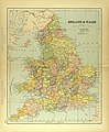 Map of England and Wales.jpg 2,931 × 3,542; 2.37 MB
