Category:OpenStreetMap maps of Paris 3e arrondissement
Media in category "OpenStreetMap maps of Paris 3e arrondissement"
The following 12 files are in this category, out of 12 total.
-
 3e Arrondissement, Paris, France - Open Street Map.png 769 × 866; 910 KB
-
 3rd arrondissement of Paris - OSM 2020.svg 1,356 × 1,504; 837 KB
-
 Archives nationales, Paris - OSM 2020.svg 512 × 354; 218 KB
-
 Buildings, Place des Vosges, Paris - OSM 2021.svg 512 × 463; 171 KB
-
 Canal Saint-Martin, Paris - OSM 2022.svg 1,694 × 2,206; 7.59 MB
-
 Hôtels particuliers, Place des Vosges, Paris - OSM 2021.svg 512 × 463; 171 KB
-
 Map of the 3rd arrondissement of Paris - OSM 2020.svg 1,356 × 1,504; 856 KB
-
 Musée Carnavalet, Paris - OSM 2022.svg 1,500 × 800; 106 KB
-
 Paris, Place des Vosges - OpenStreetMap 2017.svg 512 × 512; 23 KB
-
 Paris, Place des Vosges - OpenStreetMap.svg 366 × 350; 516 KB
-
 Place des Vosges, Paris - OSM 2021.svg 2,100 × 1,900; 174 KB
-
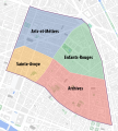 Quarters of the 3rd arrondissement of Paris - OSM 2020.svg 1,356 × 1,504; 848 KB


