Category:SVG labeled maps of administrative divisions of South Sudan (location map scheme)


.svg)


_(Paris_zoom).svg)
.svg)
,_administrative_divisions_-_de_-_colored_(multizoom).svg)
_-_colored.svg)
.svg)
,_administrative_divisions_-_Nmbrs_(multizoom).svg)
,_administrative_divisions_-_de_-_colored.svg)
_-_de_-_colored.svg)

.svg)

.svg)
Subcategories
This category has only the following subcategory.
Media in category "SVG labeled maps of administrative divisions of South Sudan (location map scheme)"
The following 9 files are in this category, out of 9 total.
-
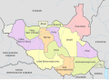
 South Sudan, administrative divisions - de - colored.svg 1,561 × 1,133; 354 KB
-
 South Sudan, administrative divisions - de - monochrome.svg 1,561 × 1,133; 354 KB
-
 South Sudan, administrative divisions - en - colored.svg 1,561 × 1,133; 310 KB
-
 South Sudan, administrative divisions - es - colored.svg 1,561 × 1,133; 387 KB
-
 South Sudan, administrative divisions - et - colored.svg 1,561 × 1,133; 305 KB
-
 South Sudan, administrative divisions - Nmbrs - colored.svg 1,561 × 1,133; 354 KB
-
 South Sudan, administrative divisions - Nmbrs - monochrome.svg 1,561 × 1,133; 354 KB
-
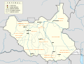
 Southern Sudan Administrative Map-bg.svg 1,500 × 1,133; 455 KB
-
 Southern Sudan Administrative Map-sr.svg 1,500 × 1,133; 374 KB


