Category:SVG labeled maps of administrative divisions of Uruguay (location map scheme)


.svg)


_(Paris_zoom).svg)
.svg)
,_administrative_divisions_-_de_-_colored_(multizoom).svg)
_-_colored.svg)
.svg)
,_administrative_divisions_-_Nmbrs_(multizoom).svg)
,_administrative_divisions_-_de_-_colored.svg)
_-_de_-_colored.svg)

.svg)

.svg)
Media in category "SVG labeled maps of administrative divisions of Uruguay (location map scheme)"
The following 16 files are in this category, out of 16 total.
-
 Administrative divisions of Uruguay (ka).svg 1,000 × 1,056; 148 KB
-
 Banda Oriental in 1816.svg 1,000 × 1,056; 103 KB
-
 Uruguay administrative divisions - ukr - colored.svg 512 × 541; 219 KB
-
 Uruguay in 1830.svg 1,000 × 1,056; 115 KB
-
 Uruguay in 1837.svg 1,000 × 1,056; 135 KB
-
 Uruguay in 1856.svg 1,000 × 1,056; 139 KB
-
 Uruguay in 1880.svg 1,000 × 1,056; 150 KB
-
 Uruguay in 1884.svg 1,000 × 1,056; 169 KB
-
 Uruguay, administrative divisions - de - colored.svg 1,000 × 1,056; 247 KB
-
 Uruguay, administrative divisions - de - monochrome.svg 1,000 × 1,056; 247 KB
-
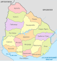
 Uruguay, administrative divisions - es - colored.svg 1,000 × 1,056; 196 KB
-
 Uruguay, administrative divisions - et - colored.svg 1,000 × 1,056; 178 KB
-
 Uruguay, administrative divisions - Nmbrs - colored.svg 1,000 × 1,056; 247 KB
-
 Uruguay, administrative divisions - Nmbrs - monochrome.svg 1,000 × 1,056; 247 KB
-
 Uruguay, administrative divisions - ru - colored.svg 1,000 × 1,056; 441 KB
-
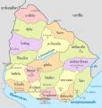 Uruguay, administrative divisions - th - colored.svg 1,000 × 1,056; 562 KB
.svg)


