| Location
|
Upload
|
Photo
|
Object
|
Cat.
|
Coordinates
|
KGS-Nr
|
| Porrentruy
|

|
yes
|


|
Archives cantonales jurassiennes
|
A
|
47°25′02″N 7°04′27″E / 47.41728°N 7.07422°E / 47.41728; 7.07422
|
8784
|
| Porrentruy
|
|
yes
|
|
jardin botanique de Porrentruy
|
A
|
47°24′51″N 7°04′40″E / 47.41422°N 7.07783°E / 47.41422; 7.07783
|
8687
|
| Porrentruy
|
|
yes
|
|
Bibliothèque cantonale jurassienne
|
A
|
47°25′02″N 7°04′27″E / 47.417347222°N 7.074155555°E / 47.417347222; 7.074155555
|
9334
|
| Porrentruy
|
|

|
|
Archives de la Bourgeoisie de Porrentruy
|
B
|
47°24′57″N 7°03′47″E / 47.41596°N 7.06318°E / 47.41596; 7.06318
|
8959
|
| Porrentruy
|
|
|
|
Archives de l'ancien Evêché de Bâle
|
A
|
47°24′57″N 7°04′29″E / 47.41579°N 7.0746°E / 47.41579; 7.0746
|
8826
|
| Porrentruy
|
|
|
|
Collection jurassienne des beaux-arts
|
B
|
47°25′02″N 7°04′27″E / 47.4173°N 7.0742°E / 47.4173; 7.0742
|
8761
|
| Porrentruy
|
|
yes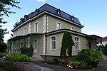
|
|
Jurassica Muséum
|
A
|
|
8687
|
| Porrentruy
|
|
yes
|
|
Musée de l'Hôtel-Dieu
|
A
|
47°25′00″N 7°04′32″E / 47.41666°N 7.07549°E / 47.41666; 7.07549
|
8686
|
| Porrentruy
|
|
yes
|
|
église et collège des Jésuites et Séminaire
|
A
|
47°24′51″N 7°04′32″E / 47.41429°N 7.07569°E / 47.41429; 7.07569
|
3568
|
| Porrentruy
|
|
yes
|
|
église St-Pierre
|
A
|
47°24′57″N 7°04′36″E / 47.4158°N 7.07663°E / 47.4158; 7.07663
|
3569
|
| Porrentruy
|
|
yes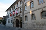
|
|
Hôtel de Gléresse
|
A
|
47°24′57″N 7°04′29″E / 47.41578°N 7.07461°E / 47.41578; 7.07461
|
3571
|
| Porrentruy
|
|
yes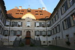
|
|
Hôtel-Dieu avec pharmacie
|
A
|
47°25′00″N 7°04′32″E / 47.41666°N 7.07549°E / 47.41666; 7.07549
|
3572
|
| Porrentruy
|
|
yes
|
|
château de Porrentruy
|
A
|
47°25′10″N 7°04′21″E / 47.41949°N 7.0724°E / 47.41949; 7.0724
|
3567
|
| Porrentruy
|
|
yes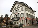
|
|
Auberge d'Ajoie (19e siècle)
|
B
|
47°25′04″N 7°04′35″E / 47.41777°N 7.07629°E / 47.41777; 7.07629
|
3575
|
| Porrentruy
|
|
yes[[File:|150x150px|Bibliothèque cantonale jurassienne, archives spéciales]]
|
|
Bibliothèque cantonale jurassienne, archives spéciales
|
B
|
47°24′57″N 7°04′29″E / 47.41577°N 7.0746°E / 47.41577; 7.0746
|
8929
|
| Porrentruy
|
|
yes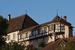
|
|
Cure catholique (18e siècle) et remparts
|
B
|
47°24′56″N 7°04′37″E / 47.41544°N 7.07696°E / 47.41544; 7.07696
|
3577
|
| Porrentruy
|
|
|
|
Ecole Ecole St-Paul
|
B
|
47°24′46″N 7°04′24″E / 47.41278°N 7.0732°E / 47.41278; 7.0732
|
10862
|
| Porrentruy
|
|
yes
|
|
Ecole Juventuti (1859)
|
B
|
47°24′55″N 7°04′35″E / 47.41531°N 7.07627°E / 47.41531; 7.07627
|
3578
|
| Porrentruy
|
|
yes
|
|
église et couvent des Ursulines (17e–19e s.)
|
B
|
47°24′59″N 7°04′34″E / 47.41626°N 7.07608°E / 47.41626; 7.07608
|
3579
|
| Porrentruy
|
|
yes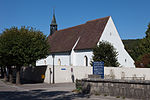
|
|
église St-Germain (13e–17e siècle) avec ancien cimetière
|
B
|
47°24′59″N 7°04′45″E / 47.4163°N 7.07927°E / 47.4163; 7.07927
|
3580
|
| Porrentruy
|
|
|
|
Fanum (temple gallo-romain)
|
B
|
47°25′42″N 7°04′38″E / 47.4284°N 7.07712°E / 47.4284; 7.07712
|
3581
|
| Porrentruy
|
|
|
|
Fonds ancien de la Bibliothèque cantonale
|
B
|
47°24′57″N 7°04′29″E / 47.41574°N 7.07465°E / 47.41574; 7.07465
|
3570
|
| Porrentruy
|
|
yes
|
|
Fontaine de la Boule dorée
|
B
|
47°24′58″N 7°04′29″E / 47.41602°N 7.07466°E / 47.41602; 7.07466
|
10854
|
| Porrentruy
|
|
yes
|
|
Fontaine de la Samaritaine (1564)
|
B
|
47°24′59″N 7°04′31″E / 47.41644°N 7.07519°E / 47.41644; 7.07519
|
3582
|
| Porrentruy
|
|
yes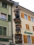
|
|
Fontaine du Suisse (1558)
|
B
|
47°25′00″N 7°04′27″E / 47.41663°N 7.07413°E / 47.41663; 7.07413
|
3583
|
| Porrentruy
|
|
yes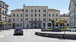
|
|
Gare CFF (1872)
|
B
|
47°25′15″N 7°04′48″E / 47.42092°N 7.07998°E / 47.42092; 7.07998
|
3584
|
| Porrentruy
|
|
yes
|
|
Grande salle du restaurant de l'Inter (1906)
|
B
|
47°25′06″N 7°04′27″E / 47.41834°N 7.07419°E / 47.41834; 7.07419
|
3585
|
| Porrentruy
|
|
yes
|
|
Hôtel de ville (1764, avec archives)
|
B
|
47°25′01″N 7°04′30″E / 47.41694°N 7.07497°E / 47.41694; 7.07497
|
3586
|
| Porrentruy
|
|
yes
|
|
Hôtel des Halles
|
B
|
47°25′02″N 7°04′26″E / 47.41724°N 7.07395°E / 47.41724; 7.07395
|
3587
|
| Porrentruy
|
|
|
|
Maison Nicol
|
B
|
47°25′05″N 7°04′20″E / 47.41816°N 7.07227°E / 47.41816; 7.07227
|
3588
|
| Porrentruy
|
|
|
|
Maison Turberg (1569)
|
B
|
47°25′06″N 7°04′24″E / 47.41824°N 7.07338°E / 47.41824; 7.07338
|
3589
|
| Porrentruy
|
|
yes
|
|
Musée jurassien des sciences naturelles
|
B
|
47°24′51″N 7°04′40″E / 47.41423°N 7.07782°E / 47.41423; 7.07782
|
3573
|
| Porrentruy
|
|
yes
|
|
Porte de France (1563, 1744)
|
B
|
47°25′09″N 7°04′25″E / 47.41913°N 7.07353°E / 47.41913; 7.07353
|
3590
|
| Porrentruy
|
|
|
|
Restaurant de l'Ours Blanc (fin 19e siècle)
|
B
|
47°24′58″N 7°04′59″E / 47.41616°N 7.0831°E / 47.41616; 7.0831
|
3591
|
| Porrentruy
|
|
yes
|
|
Tour du Séminaire
|
B
|
47°24′50″N 7°04′30″E / 47.4138°N 7.07511°E / 47.4138; 7.07511
|
10863
|
| Porrentruy
|
|
|
|
Trésor de l'Eglise Saint-Pierre
|
B
|
47°24′57″N 7°04′37″E / 47.41579°N 7.07681°E / 47.41579; 7.07681
|
9462
|
| Porrentruy
|
|
yes
|
|
Villa (environ 1895)
|
B
|
47°25′06″N 7°04′32″E / 47.41833°N 7.07544°E / 47.41833; 7.07544
|
12303
|
| Porrentruy
|
|
yes
|
|
Villa Viatte, avec intérieur et pavillon de jardin (environ1898)
|
B
|
47°25′08″N 7°04′31″E / 47.41885°N 7.07519°E / 47.41885; 7.07519
|
3592
|


