File:3-4 VIEW OF PORT SIDE AND STERN SHOWING TANEY BEING LIFTED OUT OF THE WATER ON THE PLATFORM. - U.S. Coast Guard Cutter TANEY, Pier 5, Pratt Street, Baltimore, Independent City, MD HAER MD-134-3.tif

Size of this JPG preview of this TIF file: 800 × 573 pixels. Other resolutions: 320 × 229 pixels | 640 × 458 pixels | 1,024 × 733 pixels | 1,280 × 917 pixels | 2,560 × 1,834 pixels | 5,152 × 3,690 pixels.
Original file (5,152 × 3,690 pixels, file size: 18.13 MB, MIME type: image/tiff)
Captions
Captions
Add a one-line explanation of what this file represents
Summary edit
| 3-4 VIEW OF PORT SIDE AND STERN SHOWING TANEY BEING LIFTED OUT OF THE WATER ON THE PLATFORM. - U.S. Coast Guard Cutter TANEY, Pier 5, Pratt Street, Baltimore, Independent City, MD | ||||
|---|---|---|---|---|
| Photographer |
Lowe, Jet |
|||
| Title |
3-4 VIEW OF PORT SIDE AND STERN SHOWING TANEY BEING LIFTED OUT OF THE WATER ON THE PLATFORM. - U.S. Coast Guard Cutter TANEY, Pier 5, Pratt Street, Baltimore, Independent City, MD |
|||
| Description |
Taney, Roger B; Croteau, Todd, project manager; Lowe, Jet, photographer; O'Connell, Kristen, historian |
|||
| Depicted place | Maryland; Independent City; Baltimore | |||
| Date | Documentation compiled after 1968; 2003 | |||
| Dimensions | 5 x 7 in. | |||
| Current location |
Library of Congress Prints and Photographs Division Washington, D.C. 20540 USA http://hdl.loc.gov/loc.pnp/pp.print |
|||
| Accession number |
HAER MD-134-3 |
|||
| Credit line |
|
|||
| Notes |
|
|||
| Source | https://www.loc.gov/pictures/item/md1610.photos.196299p | |||
| Permission (Reusing this file) |
|
|||

| Object location | | View this and other nearby images on: OpenStreetMap |
|---|
File history
Click on a date/time to view the file as it appeared at that time.
| Date/Time | Thumbnail | Dimensions | User | Comment | |
|---|---|---|---|---|---|
| current | 22:00, 28 July 2014 | 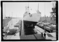 | 5,152 × 3,690 (18.13 MB) | Fæ (talk | contribs) | GWToolset: Creating mediafile for Fæ. HABS 21 July 2014 (1601:1800) |
You cannot overwrite this file.
File usage on Commons
The following page uses this file: