File:Admiralty Chart No 737 Sheet III West Coast of India From Arnol I. to Kundari I. By Captn. W.A. Tate Bombay Engineers 1827 Lieutenant R. Cogan I.N. 1828 and Commanders W. Selby, I.N. RMG F7672, Published 1859.tiff

Original file (7,176 × 4,718 pixels, file size: 96.86 MB, MIME type: image/tiff)
Captions
Captions
Summary edit
| Author |
Captain W. A. Tate; HM Admiralty; J & C Walker; Lieutenant Robert Cogan; William Beaumont Selby |
| Description |
English: Sheet III West Coast of India From Arnol I. to Kundari I. By Captn. W.A. Tate Bombay Engineers 1827 Lieutenant R. Cogan I.N. 1828 and Commanders W. Selby, I.N. Scale: circa 1:145,000 (lat). Chart with one view; magnetic variation marked. Coordiantes given. Backed with cloth.
Bibliography: Number 113 in a folder made up by J.D. Potter Ltd.; see 298:8/3(a) for original folder list. |
| Date | 1884 |
| Dimensions | Sheet: 98.5 cm x 65.5 cm |
| Notes | This record was added as part of the 2009-2010 pre 1900 charts transcription project. |
| Source/Photographer | http://collections.rmg.co.uk/collections/objects/552389 |
| Permission (Reusing this file) |
The original artefact or artwork has been assessed as public domain by age, and faithful reproductions of the two dimensional work are also public domain. No permission is required for reuse for any purpose. The text of this image record has been derived from the Royal Museums Greenwich catalogue and image metadata. Individual data and facts such as date, author and title are not copyrightable, but reuse of longer descriptive text from the catalogue may not be considered fair use. Reuse of the text must be attributed to the "National Maritime Museum, Greenwich, London" and a Creative Commons CC-BY-NC-SA-3.0 license may apply if not rewritten. Refer to Royal Museums Greenwich copyright. |
| Identifier | Acquisition Number: N82-18 Admiralty Chart Number: 737 GGCC: 254:6 id number: G254:6/73 |
| Collection | Charts and maps |
Licensing edit
|
This is a faithful photographic reproduction of a two-dimensional, public domain work of art. The work of art itself is in the public domain for the following reason:
The official position taken by the Wikimedia Foundation is that "faithful reproductions of two-dimensional public domain works of art are public domain".
This photographic reproduction is therefore also considered to be in the public domain in the United States. In other jurisdictions, re-use of this content may be restricted; see Reuse of PD-Art photographs for details. | ||||
File history
Click on a date/time to view the file as it appeared at that time.
| Date/Time | Thumbnail | Dimensions | User | Comment | |
|---|---|---|---|---|---|
| current | 10:35, 5 September 2017 | 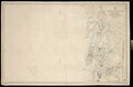 | 7,176 × 4,718 (96.86 MB) | Fæ (talk | contribs) | Royal Museums Greenwich Charts and maps, http://collections.rmg.co.uk/collections/objects/552389 #940 |
You cannot overwrite this file.
File usage on Commons
The following 2 pages use this file:
- File:Admiralty Chart No 737 Sheet III West Coast of India From Arnol I. to Kundari I. By Captn. W.A. Tate Bombay Engineers 1827 Lieutenant R. Cogan I.N. 1828 and Commanders W. Selby, I.N. RMG F7672, Published 1859.tiff
- File:Sheet III West Coast of India From Arnol I. to Kundari I. By Captn. W.A. Tate Bombay Engineers 1827 Lieutenant R. Cogan I.N. 1828 and Commanders W. Selby, I.N. RMG F7672.tiff (file redirect)