File:Bridge over west prong, Little Pigeon River. - Great Smoky Mountains National Park Roads and Bridges, Newfound Gap Road, Between Gatlinburg, TN and Cherokee, NC, Gatlinburg, HAER TENN,78-GAT.V,6A-11.tif

Size of this JPG preview of this TIF file: 743 × 600 pixels. Other resolutions: 298 × 240 pixels | 595 × 480 pixels | 952 × 768 pixels | 1,269 × 1,024 pixels | 2,538 × 2,048 pixels | 5,000 × 4,035 pixels.
Original file (5,000 × 4,035 pixels, file size: 19.24 MB, MIME type: image/tiff)
Captions
Captions
Add a one-line explanation of what this file represents
Summary edit
| Bridge over west prong, Little Pigeon River. - Great Smoky Mountains National Park Roads and Bridges, Newfound Gap Road, Between Gatlinburg, TN and Cherokee, NC, Gatlinburg, Sevier County, TN | ||||
|---|---|---|---|---|
| Photographer |
Haas, David |
|||
| Title |
Bridge over west prong, Little Pigeon River. - Great Smoky Mountains National Park Roads and Bridges, Newfound Gap Road, Between Gatlinburg, TN and Cherokee, NC, Gatlinburg, Sevier County, TN |
|||
| Description |
Bureau of Public Roads; Cammerer, Arno B; Bass, C N; Swain, C E; Tennessee Highway Commission; Peterson, Charles; Eakin, J Ross; Morrell, John; Spelman, H J; Lee, W I; Ludgate, Rowell; Arthur, Jack; Arundel Corporation; R B Tyler Company; C Y Thomason Company; King, Willis; Breslin Construction Company; Rockefeller, John D; Vint, Thomas; Olmsted, Frederick Law; Hubbard, Henry; Rice, Henry; Troitino and Brown Construction; H F Ramsey Company; Blalock Lumber Company; Clement Brothers Company; Hart Construction; Luten Bridge Company; Lupyak, Edward, field team project manager; Great Smoky Mountains National Park, sponsor; National Park Service Roads and Parkway Program, sponsor; Federal Lands Highway Program, sponsor; Croteau, Todd, project manager; Quin, Richard, project manager |
|||
| Depicted place | Tennessee; Sevier County; Gatlinburg | |||
| Date | 1996 | |||
| Dimensions | 4 x 5 in. | |||
| Current location |
Library of Congress Prints and Photographs Division Washington, D.C. 20540 USA http://hdl.loc.gov/loc.pnp/pp.print |
|||
| Accession number |
HAER TENN,78-GAT.V,6A-11 |
|||
| Credit line |
|
|||
| Notes |
|
|||
| Source | https://www.loc.gov/pictures/item/tn0278.photos.365839p | |||
| Permission (Reusing this file) |
|
|||

File history
Click on a date/time to view the file as it appeared at that time.
| Date/Time | Thumbnail | Dimensions | User | Comment | |
|---|---|---|---|---|---|
| current | 02:27, 2 August 2014 | 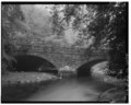 | 5,000 × 4,035 (19.24 MB) | Fæ (talk | contribs) | GWToolset: Creating mediafile for Fæ. HABS 2014-08-01 (3201:3400) |
You cannot overwrite this file.
File usage on Commons
The following page uses this file: