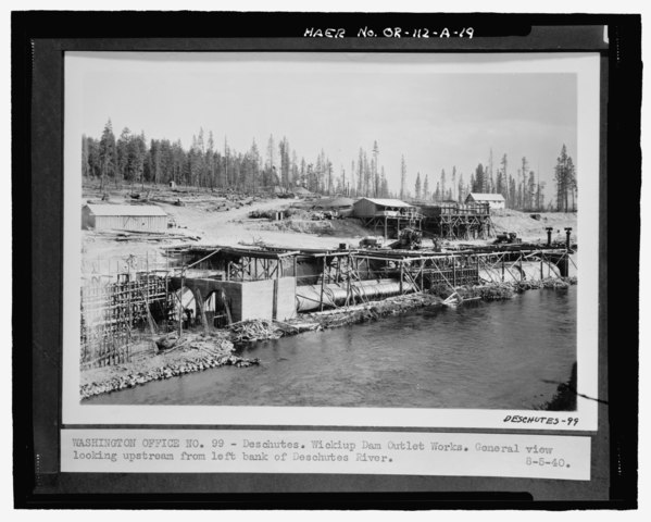
File:DESCHUTES. WICKIUP DAM OUTLET WORKS. GENERAL VIEW LOOKING UPSTREAM FROM LEFT BANK OF DESCHUTES RIVER. Photocopy of historic photograph (original photograph on file at National HAER OR-112-A-19.tif

Size of this JPG preview of this TIF file: 748 × 600 pixels. Other resolutions: 299 × 240 pixels | 599 × 480 pixels | 958 × 768 pixels | 1,277 × 1,024 pixels | 2,553 × 2,048 pixels | 5,468 × 4,386 pixels.
Original file (5,468 × 4,386 pixels, file size: 22.88 MB, MIME type: image/tiff)
Captions
Captions
Add a one-line explanation of what this file represents
Summary edit
| Photographer |
McKenney, Pamela Related names:
|
|||
| Title |
DESCHUTES. WICKIUP DAM OUTLET WORKS. GENERAL VIEW LOOKING UPSTREAM FROM LEFT BANK OF DESCHUTES RIVER. Photocopy of historic photograph (original photograph on file at National Archives, Rocky Mountain Region, Denver, CO). Unknown USBR photographer, August 5, 1940 - Wickiup Dam, Outlet Works, Deschutes River, La Pine, Deschutes County, OR |
|||
| Depicted place | Oregon; Deschutes County; La Pine | |||
| Date | 2000 | |||
| Dimensions | 4 x 5 in. | |||
| Current location |
Library of Congress Prints and Photographs Division Washington, D.C. 20540 USA http://hdl.loc.gov/loc.pnp/pp.print |
|||
| Accession number |
HAER OR-112-A-19 |
|||
| Credit line |
|
|||
| Notes |
|
|||
| Source | https://www.loc.gov/pictures/item/or0569.photos.224735p | |||
| Permission (Reusing this file) |
|

| Object location | | View this and other nearby images on: OpenStreetMap |
|---|
File history
Click on a date/time to view the file as it appeared at that time.
| Date/Time | Thumbnail | Dimensions | User | Comment | |
|---|---|---|---|---|---|
| current | 12:16, 2 August 2014 |  | 5,468 × 4,386 (22.88 MB) | Fæ (talk | contribs) | GWToolset: Creating mediafile for Fæ. HABS 2014-08-01 2601-2900 missing |
You cannot overwrite this file.
File usage on Commons
The following page uses this file: