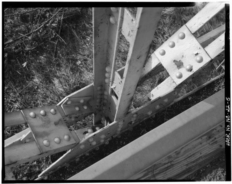
File:DETAIL, RIVET JOINT - Bridge No. 28, Spanning Flatt River at State Route 1004, Durham, Durham County, NC HAER NC,32-DURM.V,1-5.tif
Size of this JPG preview of this TIF file: 752 × 599 pixels. Other resolutions: 301 × 240 pixels | 602 × 480 pixels | 963 × 768 pixels | 1,280 × 1,020 pixels | 2,560 × 2,041 pixels | 5,000 × 3,986 pixels.
Original file (5,000 × 3,986 pixels, file size: 19.01 MB, MIME type: image/tiff)
Captions
Captions
Add a one-line explanation of what this file represents
Summary edit
| DETAIL, RIVET JOINT - Bridge No. 28, Spanning Flatt River at State Route 1004, Durham, Durham County, NC | ||||
|---|---|---|---|---|
| Photographer |
Related names:
|
|||
| Title |
DETAIL, RIVET JOINT - Bridge No. 28, Spanning Flatt River at State Route 1004, Durham, Durham County, NC |
|||
| Depicted place | North Carolina; Durham County; Durham | |||
| Date | Documentation compiled after 1968 | |||
| Dimensions | height: 4 in (10.1 cm); width: 5 in (12.7 cm) | |||
| Current location |
Library of Congress Prints and Photographs Division Washington, D.C. 20540 USA http://hdl.loc.gov/loc.pnp/pp.print |
|||
| Accession number |
HAER NC,32-DURM.V,1-5 |
|||
| Credit line |
|
|||
| Notes |
|
|||
| Source | https://www.loc.gov/pictures/item/nc0367.photos.101959p | |||
| Permission (Reusing this file) |
|
|||

| Object location | | View this and other nearby images on: OpenStreetMap |
|---|
File history
Click on a date/time to view the file as it appeared at that time.
| Date/Time | Thumbnail | Dimensions | User | Comment | |
|---|---|---|---|---|---|
| current | 22:40, 28 July 2014 |  | 5,000 × 3,986 (19.01 MB) | Fæ (talk | contribs) | GWToolset: Creating mediafile for Fæ. HABS 24 July 2014 (2001:2300) |
You cannot overwrite this file.
File usage on Commons
The following page uses this file: