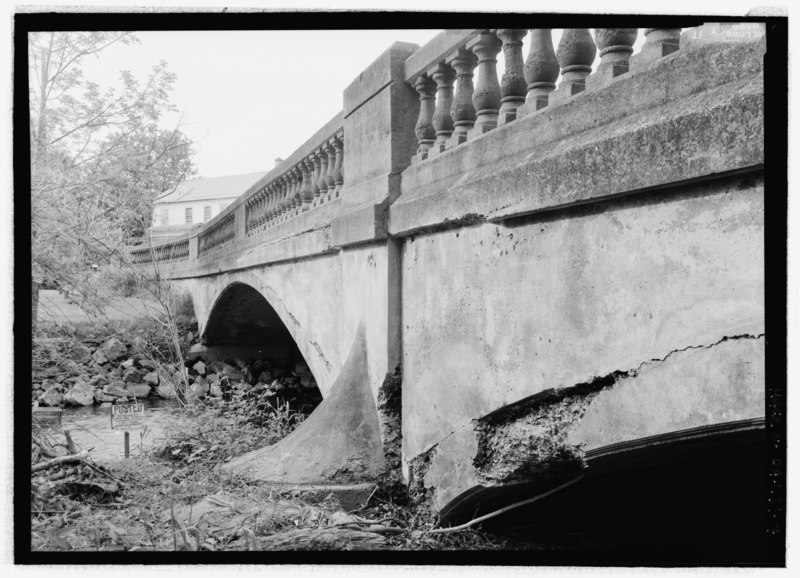
File:DETAIL CENTRAL PIER (SKEWBACK) WITH BREAKWATER, UPSTREAM (EAST) SIDE. NOTE FRACTURES ALONG BARREL ARCH EXTRADOS. - Roaring Creek Bridge, State Road 2005 spanning Roaring Creek in Locust HAER PA-631-7.tif
Size of this JPG preview of this TIF file: 800 × 579 pixels. Other resolutions: 320 × 231 pixels | 640 × 463 pixels | 1,024 × 741 pixels | 1,280 × 926 pixels | 2,560 × 1,852 pixels | 5,175 × 3,743 pixels.
Original file (5,175 × 3,743 pixels, file size: 18.48 MB, MIME type: image/tiff)
Captions
Captions
Add a one-line explanation of what this file represents
Summary edit
| DETAIL CENTRAL PIER (SKEWBACK) WITH BREAKWATER, UPSTREAM (EAST) SIDE. NOTE FRACTURES ALONG BARREL ARCH EXTRADOS. - Roaring Creek Bridge, State Road 2005 spanning Roaring Creek in Locust Township, Slabtown, Columbia County, PA | ||||
|---|---|---|---|---|
| Title |
DETAIL CENTRAL PIER (SKEWBACK) WITH BREAKWATER, UPSTREAM (EAST) SIDE. NOTE FRACTURES ALONG BARREL ARCH EXTRADOS. - Roaring Creek Bridge, State Road 2005 spanning Roaring Creek in Locust Township, Slabtown, Columbia County, PA |
|||
| Description |
Ferro-Concrete Company; Fink, J A; McIlvaine, J S; Reinard Brothers; Welliver, Charles E; Lenhard, C Fred; Fleckenstine, George; Smith, Charles E; Fink, G A; Burnham, Daniel; Croteau, Todd, project manager; Pennsylvania Department of Transportation, sponsor; Pennsylvania Historical and Museum Commission, sponsor; Christianson, Justine, transmitter; Lowe, Jet, photographer; Vidutis, Richard, historian |
|||
| Depicted place | Pennsylvania; Columbia County; Slabtown | |||
| Date | Documentation compiled after 1968 | |||
| Dimensions | height: 5 in (12.7 cm); width: 7 in (17.7 cm) | |||
| Current location |
Library of Congress Prints and Photographs Division Washington, D.C. 20540 USA http://hdl.loc.gov/loc.pnp/pp.print |
|||
| Accession number |
HAER PA-631-7 |
|||
| Credit line |
|
|||
| Notes |
|
|||
| Source | https://www.loc.gov/pictures/item/pa3999.photos.202983p | |||
| Permission (Reusing this file) |
|
|||

| Object location | | View this and other nearby images on: OpenStreetMap |
|---|
File history
Click on a date/time to view the file as it appeared at that time.
| Date/Time | Thumbnail | Dimensions | User | Comment | |
|---|---|---|---|---|---|
| current | 08:33, 1 August 2014 |  | 5,175 × 3,743 (18.48 MB) | Fæ (talk | contribs) | GWToolset: Creating mediafile for Fæ. HABS 31 July 2014 (3000:3200) |
You cannot overwrite this file.
File usage on Commons
The following page uses this file: