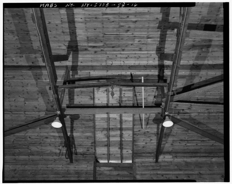
File:DETAIL OF ROOF TRUSS SYSTEM, FACING EAST, THIRD BAY Showing bottom chords and diagonal braces of roof trusses, hoist I-beam and pulley. - U.S. Military Academy, Ice House, HABS NY,36-WEPO,1-58-16.tif
Size of this JPG preview of this TIF file: 754 × 600 pixels. Other resolutions: 302 × 240 pixels | 604 × 480 pixels | 966 × 768 pixels | 1,280 × 1,018 pixels | 2,560 × 2,035 pixels | 4,939 × 3,927 pixels.
Original file (4,939 × 3,927 pixels, file size: 18.5 MB, MIME type: image/tiff)
Captions
Captions
Add a one-line explanation of what this file represents
Summary edit
| DETAIL OF ROOF TRUSS SYSTEM, FACING EAST, THIRD BAY Showing bottom chords and diagonal braces of roof trusses, hoist I-beam and pulley. - U.S. Military Academy, Ice House, Mills Road at Howze Place, West Point, Orange County, NY | ||||
|---|---|---|---|---|
| Title |
DETAIL OF ROOF TRUSS SYSTEM, FACING EAST, THIRD BAY Showing bottom chords and diagonal braces of roof trusses, hoist I-beam and pulley. - U.S. Military Academy, Ice House, Mills Road at Howze Place, West Point, Orange County, NY |
|||
| Depicted place | New York; Orange County; West Point | |||
| Date | Documentation compiled after 1933 | |||
| Dimensions | 4 x 5 in. | |||
| Current location |
Library of Congress Prints and Photographs Division Washington, D.C. 20540 USA http://hdl.loc.gov/loc.pnp/pp.print |
|||
| Accession number |
HABS NY,36-WEPO,1-58-16 |
|||
| Credit line |
|
|||
| Notes |
|
|||
| References |
|
|||
| Source | https://www.loc.gov/pictures/item/ny1542.photos.121833p | |||
| Permission (Reusing this file) |
|
|||

| Object location | | View this and other nearby images on: OpenStreetMap |
|---|
File history
Click on a date/time to view the file as it appeared at that time.
| Date/Time | Thumbnail | Dimensions | User | Comment | |
|---|---|---|---|---|---|
| current | 18:41, 29 July 2014 |  | 4,939 × 3,927 (18.5 MB) | Fæ (talk | contribs) | GWToolset: Creating mediafile for Fæ. HABS 24 July 2014 (2301:2600) |
You cannot overwrite this file.
File usage on Commons
The following page uses this file: