File:DETAIL SHOWING JUNCTION OF MIDDLE ADIT TO LEFT AND VIEW EAST THROUGH TUNNEL. - Wawona Tunnel, Wawona Road through Turtleback Dome, Yosemite Village, Mariposa County, CA HAER CAL,22-YOSEM,26-11.tif

Size of this JPG preview of this TIF file: 486 × 599 pixels. Other resolutions: 195 × 240 pixels | 389 × 480 pixels | 623 × 768 pixels | 831 × 1,024 pixels | 1,662 × 2,048 pixels | 4,057 × 5,000 pixels.
Original file (4,057 × 5,000 pixels, file size: 19.35 MB, MIME type: image/tiff)
Captions
Captions
Add a one-line explanation of what this file represents
Summary edit
| DETAIL SHOWING JUNCTION OF MIDDLE ADIT TO LEFT AND VIEW EAST THROUGH TUNNEL. - Wawona Tunnel, Wawona Road through Turtleback Dome, Yosemite Village, Mariposa County, CA | ||||
|---|---|---|---|---|
| Photographer |
Grogan, Brian C. Related names:
|
|||
| Title |
DETAIL SHOWING JUNCTION OF MIDDLE ADIT TO LEFT AND VIEW EAST THROUGH TUNNEL. - Wawona Tunnel, Wawona Road through Turtleback Dome, Yosemite Village, Mariposa County, CA |
|||
| Depicted place | California; Mariposa County; Yosemite Village | |||
| Date | 1991 | |||
| Dimensions | 4 x 5 in. | |||
| Current location |
Library of Congress Prints and Photographs Division Washington, D.C. 20540 USA http://hdl.loc.gov/loc.pnp/pp.print |
|||
| Accession number |
HAER CAL,22-YOSEM,26-11 |
|||
| Credit line |
|
|||
| Notes |
|
|||
| Source | https://www.loc.gov/pictures/item/ca1652.photos.041866p | |||
| Permission (Reusing this file) |
|
|||

| Object location | | View this and other nearby images on: OpenStreetMap |
|---|
File history
Click on a date/time to view the file as it appeared at that time.
| Date/Time | Thumbnail | Dimensions | User | Comment | |
|---|---|---|---|---|---|
| current | 05:12, 4 July 2014 | 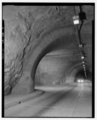 | 4,057 × 5,000 (19.35 MB) | Fæ (talk | contribs) | GWToolset: Creating mediafile for Fæ. HABS batch upload 2 July 2014 (301:400) |
You cannot overwrite this file.
File usage on Commons
The following page uses this file: