File:DETAIL VIEW LOOKING NORTH, SHOWING WEST - Cincinnati Suspension Bridge, Spanning Ohio River, Cincinnati, Hamilton County, OH HAER OHIO,31-CINT,45-7.tif
Size of this JPG preview of this TIF file: 437 × 599 pixels. Other resolutions: 175 × 240 pixels | 350 × 480 pixels | 560 × 768 pixels | 747 × 1,024 pixels | 1,493 × 2,048 pixels | 3,637 × 4,988 pixels.
Original file (3,637 × 4,988 pixels, file size: 17.3 MB, MIME type: image/tiff)
Captions
Captions
Add a one-line explanation of what this file represents
Summary edit
| DETAIL VIEW LOOKING NORTH, SHOWING WEST - Cincinnati Suspension Bridge, Spanning Ohio River, Cincinnati, Hamilton County, OH | ||||
|---|---|---|---|---|
| Title |
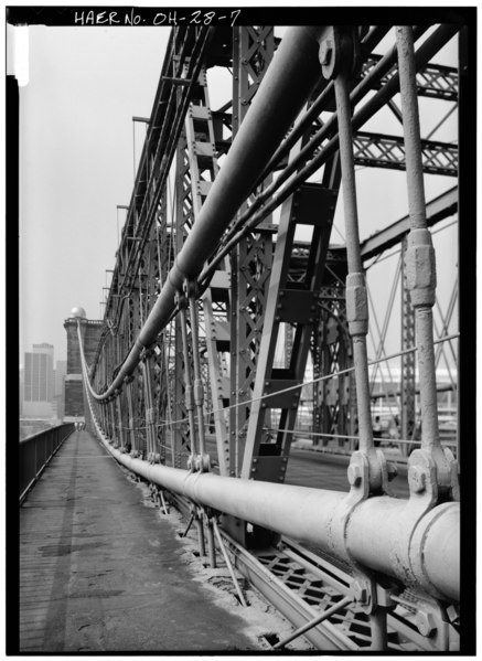
DETAIL VIEW LOOKING NORTH, SHOWING WEST - Cincinnati Suspension Bridge, Spanning Ohio River, Cincinnati, Hamilton County, OH |
|||
| Depicted place | Ohio; Hamilton County; Cincinnati | |||
| Date | Documentation compiled after 1968 | |||
| Dimensions | 5 x 7 in. | |||
| Current location |
Library of Congress Prints and Photographs Division Washington, D.C. 20540 USA http://hdl.loc.gov/loc.pnp/pp.print |
|||
| Accession number |
HAER OHIO,31-CINT,45-7 |
|||
| Credit line |
|
|||
| Notes |
|
|||
| Source | https://www.loc.gov/pictures/item/oh0104.photos.127314p | |||
| Permission (Reusing this file) |
|
|||

| Object location | | View this and other nearby images on: OpenStreetMap |
|---|
File history
Click on a date/time to view the file as it appeared at that time.
| Date/Time | Thumbnail | Dimensions | User | Comment | |
|---|---|---|---|---|---|
| current | 10:48, 30 July 2014 |  | 3,637 × 4,988 (17.3 MB) | Fæ (talk | contribs) | GWToolset: Creating mediafile for Fæ. HABS 30 July 2014 (2601:2900) |
You cannot overwrite this file.
File usage on Commons
The following page uses this file: