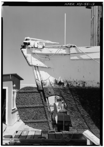
File:DETAIL VIEW OF STARBOARD ELEVATION OF DUCKTAIL AND RUDDER ASSEMBLY - Bugeye "Louise Travers", Intersection of Routes 2 and 4, Solomons, Calvert County, MD HAER MD,5-SOLOM,1-13.tif

Size of this JPG preview of this TIF file: 426 × 599 pixels. Other resolutions: 170 × 240 pixels | 341 × 480 pixels | 546 × 768 pixels | 728 × 1,024 pixels | 1,456 × 2,048 pixels | 3,821 × 5,374 pixels.
Original file (3,821 × 5,374 pixels, file size: 19.59 MB, MIME type: image/tiff)
Captions
Captions
Add a one-line explanation of what this file represents
Summary edit
| DETAIL VIEW OF STARBOARD ELEVATION OF DUCKTAIL AND RUDDER ASSEMBLY - Bugeye "Louise Travers", Intersection of Routes 2 and 4, Solomons, Calvert County, MD | ||||
|---|---|---|---|---|
| Title |
DETAIL VIEW OF STARBOARD ELEVATION OF DUCKTAIL AND RUDDER ASSEMBLY - Bugeye "Louise Travers", Intersection of Routes 2 and 4, Solomons, Calvert County, MD |
|||
| Description |
Marsh, James T |
|||
| Depicted place | Maryland; Calvert County; Solomons | |||
| Date | Documentation compiled after 1968 | |||
| Dimensions | 5 x 7 in. | |||
| Current location |
Library of Congress Prints and Photographs Division Washington, D.C. 20540 USA http://hdl.loc.gov/loc.pnp/pp.print |
|||
| Accession number |
HAER MD,5-SOLOM,1-13 |
|||
| Credit line |
|
|||
| Notes |
|
|||
| Source | https://www.loc.gov/pictures/item/md1071.photos.086999p | |||
| Permission (Reusing this file) |
|
|||

| Object location | | View this and other nearby images on: OpenStreetMap |
|---|
File history
Click on a date/time to view the file as it appeared at that time.
| Date/Time | Thumbnail | Dimensions | User | Comment | |
|---|---|---|---|---|---|
| current | 00:38, 23 July 2014 |  | 3,821 × 5,374 (19.59 MB) | Fæ (talk | contribs) | GWToolset: Creating mediafile for Fæ. HABS 21 July 2014 (1601:1800) |
You cannot overwrite this file.
File usage on Commons
The following page uses this file: