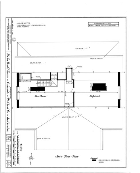
File:DeBruhl-Marshall House, 1401 Laurel Street, Columbia, Richland County, SC HABS SC,40-COLUM,1- (sheet 4 of 13).tif
Size of this JPG preview of this TIF file: 487 × 599 pixels. Other resolutions: 195 × 240 pixels | 390 × 480 pixels | 624 × 768 pixels | 832 × 1,024 pixels | 1,665 × 2,048 pixels | 7,584 × 9,328 pixels.
Original file (7,584 × 9,328 pixels, file size: 285 KB, MIME type: image/tiff)
Captions
Captions
Add a one-line explanation of what this file represents
Summary edit
| HABS SC,40-COLUM,1- (sheet 4 of 13) - DeBruhl-Marshall House, 1401 Laurel Street, Columbia, Richland County, SC | ||||
|---|---|---|---|---|
| Title |
HABS SC,40-COLUM,1- (sheet 4 of 13) - DeBruhl-Marshall House, 1401 Laurel Street, Columbia, Richland County, SC |
|||
| Description |
Mills, Robert; DeBruhl, Robert |
|||
| Depicted place | South Carolina; Richland County; Columbia | |||
| Date | Documentation compiled after 1933 | |||
| Dimensions | 19 x 24 in. (B size) | |||
| Current location |
Library of Congress Prints and Photographs Division Washington, D.C. 20540 USA http://hdl.loc.gov/loc.pnp/pp.print |
|||
| Accession number |
HABS SC,40-COLUM,1- (sheet 4 of 13) |
|||
| Credit line |
|
|||
| Notes |
|
|||
| Source | https://www.loc.gov/pictures/item/sc0070.sheet.00004a | |||
| Permission (Reusing this file) |
|
|||
| Other versions |
.png) .png) .png) .png) .png) .png) .png) .png) .png) .png) .png) .png) .png) .png) |
|||

| Object location | | View this and other nearby images on: OpenStreetMap |
|---|
File history
Click on a date/time to view the file as it appeared at that time.
| Date/Time | Thumbnail | Dimensions | User | Comment | |
|---|---|---|---|---|---|
| current | 23:46, 1 August 2014 |  | 7,584 × 9,328 (285 KB) | Fæ (talk | contribs) | GWToolset: Creating mediafile for Fæ. HABS 31 July 2014 (3000:3200) |
You cannot overwrite this file.
File usage on Commons
The following page uses this file: