File:Detail, anchorage at northeast abutment - St. John's Bridge, Spans Willamette River at US Highway 30, Portland, Multnomah County, OR HAER ORE,26-PORT,13-10.tif
Size of this JPG preview of this TIF file: 431 × 599 pixels. Other resolutions: 172 × 240 pixels | 345 × 480 pixels | 552 × 768 pixels | 736 × 1,024 pixels | 1,473 × 2,048 pixels | 3,596 × 5,000 pixels.
Original file (3,596 × 5,000 pixels, file size: 17.15 MB, MIME type: image/tiff)
Captions
Captions
Add a one-line explanation of what this file represents
Summary edit
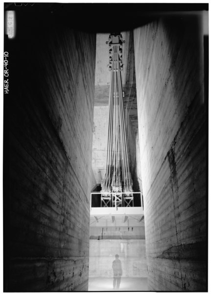
| Detail, anchorage at northeast abutment - St. John's Bridge, Spans Willamette River at US Highway 30, Portland, Multnomah County, OR | ||||
|---|---|---|---|---|
| Photographer |
Related names:
|
|||
| Title |
Detail, anchorage at northeast abutment - St. John's Bridge, Spans Willamette River at US Highway 30, Portland, Multnomah County, OR |
|||
| Depicted place | Oregon; Multnomah County; Portland | |||
| Date | Documentation compiled after 1968 | |||
| Dimensions | 5 x 7 in. | |||
| Current location |
Library of Congress Prints and Photographs Division Washington, D.C. 20540 USA http://hdl.loc.gov/loc.pnp/pp.print |
|||
| Accession number |
HAER ORE,26-PORT,13-10 |
|||
| Credit line |
|
|||
| Notes |
|
|||
| Source | https://www.loc.gov/pictures/item/or0307.photos.130780p | |||
| Permission (Reusing this file) |
|
|||

| Object location | | View this and other nearby images on: OpenStreetMap |
|---|
File history
Click on a date/time to view the file as it appeared at that time.
| Date/Time | Thumbnail | Dimensions | User | Comment | |
|---|---|---|---|---|---|
| current | 06:59, 2 August 2014 |  | 3,596 × 5,000 (17.15 MB) | Fæ (talk | contribs) | GWToolset: Creating mediafile for Fæ. HABS 2014-08-01 2601-2900 missing |
You cannot overwrite this file.
File usage on Commons
The following page uses this file: