File:EAST ELEVATION WITH GRADUATED MEASURING POLE. VIEW FACING WEST - U.S. Naval Base, Pearl Harbor, Ford Island 5-Inch Antiaircraft Battery, Battery Command Center, Ford Island, Pearl City, HAER HI-85-A-7.tif
Size of this JPG preview of this TIF file: 755 × 600 pixels. Other resolutions: 302 × 240 pixels | 605 × 480 pixels | 967 × 768 pixels | 1,280 × 1,016 pixels | 2,560 × 2,033 pixels | 5,040 × 4,002 pixels.
Original file (5,040 × 4,002 pixels, file size: 38.49 MB, MIME type: image/tiff)
Captions
Captions
Add a one-line explanation of what this file represents
Summary edit
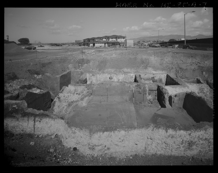
| EAST ELEVATION WITH GRADUATED MEASURING POLE. VIEW FACING WEST - U.S. Naval Base, Pearl Harbor, Ford Island 5-Inch Antiaircraft Battery, Battery Command Center, Ford Island, Pearl City, Honolulu County, HI | ||||
|---|---|---|---|---|
| Photographer |
Franzen, David Related names:
|
|||
| Title |
EAST ELEVATION WITH GRADUATED MEASURING POLE. VIEW FACING WEST - U.S. Naval Base, Pearl Harbor, Ford Island 5-Inch Antiaircraft Battery, Battery Command Center, Ford Island, Pearl City, Honolulu County, HI |
|||
| Depicted place | Hawaii; Honolulu County; Pearl City | |||
| Date | 2007 | |||
| Dimensions | 4 x 5 in. | |||
| Current location |
Library of Congress Prints and Photographs Division Washington, D.C. 20540 USA http://hdl.loc.gov/loc.pnp/pp.print |
|||
| Accession number |
HAER HI-85-A-7 |
|||
| Credit line |
|
|||
| Notes |
|
|||
| References |
|
|||
| Source | https://www.loc.gov/pictures/item/hi0889.photos.576799p | |||
| Permission (Reusing this file) |
|
|||

| Object location | | View this and other nearby images on: OpenStreetMap |
|---|
File history
Click on a date/time to view the file as it appeared at that time.
| Date/Time | Thumbnail | Dimensions | User | Comment | |
|---|---|---|---|---|---|
| current | 05:37, 13 July 2014 |  | 5,040 × 4,002 (38.49 MB) | Fæ (talk | contribs) | GWToolset: Creating mediafile for Fæ. HABS 11 July 2014 (1001:1200) |
You cannot overwrite this file.
File usage on Commons
The following page uses this file: