File:EAST SIDE - Thomas J. Bruce House, State Route 8 (south side), Vanceburg, Lewis County, KY HABS KY,68-VANC.V,2-2.tif

Size of this JPG preview of this TIF file: 478 × 599 pixels. Other resolutions: 191 × 240 pixels | 383 × 480 pixels | 612 × 768 pixels | 817 × 1,024 pixels | 1,633 × 2,048 pixels | 3,961 × 4,966 pixels.
Original file (3,961 × 4,966 pixels, file size: 18.76 MB, MIME type: image/tiff)
Captions
Captions
Add a one-line explanation of what this file represents
| EAST SIDE - Thomas J. Bruce House, State Route 8 (south side), Vanceburg, Lewis County, KY | ||||
|---|---|---|---|---|
| Title |
EAST SIDE - Thomas J. Bruce House, State Route 8 (south side), Vanceburg, Lewis County, KY |
|||
| Depicted place | Kentucky; Lewis County; Vanceburg | |||
| Date | Documentation compiled after 1933 | |||
| Dimensions | 4 x 5 in. | |||
| Current location |
Library of Congress Prints and Photographs Division Washington, D.C. 20540 USA http://hdl.loc.gov/loc.pnp/pp.print |
|||
| Accession number |
HABS KY,68-VANC.V,2-2 |
|||
| Credit line |
|
|||
| Notes |
|
|||
| Source | https://www.loc.gov/pictures/item/ky0183.photos.071403p | |||
| Permission (Reusing this file) |
|
|||

| Object location | | View this and other nearby images on: OpenStreetMap |
|---|
File history
Click on a date/time to view the file as it appeared at that time.
| Date/Time | Thumbnail | Dimensions | User | Comment | |
|---|---|---|---|---|---|
| current | 23:57, 19 July 2014 | 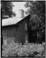 | 3,961 × 4,966 (18.76 MB) | Fæ (talk | contribs) | GWToolset: Creating mediafile for Fæ. HABS 16 July 2014 (1201:1400) |
You cannot overwrite this file.
File usage on Commons
The following page uses this file: