File:EXPANSION JOINT ON SOUTHWESTERN ABUTMENT (EXPANSION END) - Thompson's Bridge, Spanning Brandywine River on Delaware State Route 92, Wilmington, New Castle County, DE HAER DEL,2-WILM.V,7-17.tif
Size of this JPG preview of this TIF file: 750 × 600 pixels. Other resolutions: 300 × 240 pixels | 600 × 480 pixels | 961 × 768 pixels | 1,280 × 1,023 pixels | 2,560 × 2,047 pixels | 5,000 × 3,998 pixels.
Original file (5,000 × 3,998 pixels, file size: 19.07 MB, MIME type: image/tiff)
Captions
Captions
Add a one-line explanation of what this file represents
Summary edit
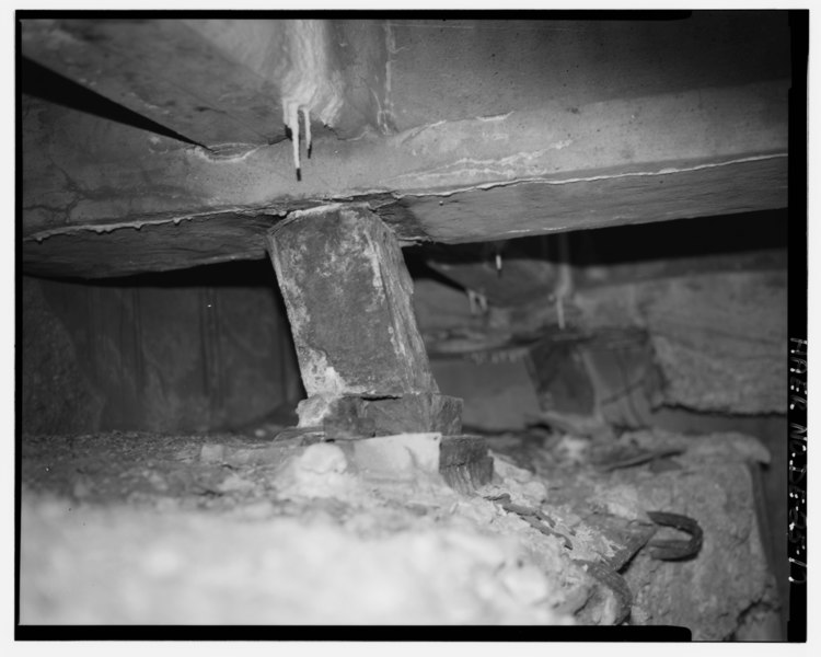
| EXPANSION JOINT ON SOUTHWESTERN ABUTMENT (EXPANSION END) - Thompson's Bridge, Spanning Brandywine River on Delaware State Route 92, Wilmington, New Castle County, DE | ||||
|---|---|---|---|---|
| Photographer |
Related names:
|
|||
| Title |
EXPANSION JOINT ON SOUTHWESTERN ABUTMENT (EXPANSION END) - Thompson's Bridge, Spanning Brandywine River on Delaware State Route 92, Wilmington, New Castle County, DE |
|||
| Depicted place | Delaware; New Castle County; Wilmington | |||
| Date | Documentation compiled after 1968 | |||
| Dimensions | 4 x 5 in. | |||
| Current location |
Library of Congress Prints and Photographs Division Washington, D.C. 20540 USA http://hdl.loc.gov/loc.pnp/pp.print |
|||
| Accession number |
HAER DEL,2-WILM.V,7-17 |
|||
| Credit line |
|
|||
| Notes |
|
|||
| Source | https://www.loc.gov/pictures/item/de0336.photos.183998p | |||
| Permission (Reusing this file) |
|
|||

| Object location | | View this and other nearby images on: OpenStreetMap |
|---|
File history
Click on a date/time to view the file as it appeared at that time.
| Date/Time | Thumbnail | Dimensions | User | Comment | |
|---|---|---|---|---|---|
| current | 20:40, 10 July 2014 |  | 5,000 × 3,998 (19.07 MB) | Fæ (talk | contribs) | GWToolset: Creating mediafile for Fæ. HABS 09 July 2014 (801:1000) |
You cannot overwrite this file.
File usage on Commons
The following page uses this file: