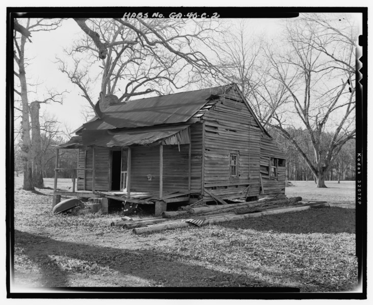
File:East front and north side - Rodgers-Buchanan Farm, Tenant House B, State Highway 3-U.S. Highway 19, Lower Five Points Road and Cornwell Road, Sumter, Sumter County, GA HABS GA-40-C-2.tif
Size of this JPG preview of this TIF file: 732 × 599 pixels. Other resolutions: 293 × 240 pixels | 586 × 480 pixels | 938 × 768 pixels | 1,251 × 1,024 pixels | 2,501 × 2,048 pixels | 5,169 × 4,233 pixels.
Original file (5,169 × 4,233 pixels, file size: 20.87 MB, MIME type: image/tiff)
Captions
Captions
Add a one-line explanation of what this file represents
Summary edit
| East front and north side - Rodgers-Buchanan Farm, Tenant House B, State Highway 3-U.S. Highway 19, Lower Five Points Road and Cornwell Road, Sumter, Sumter County, GA | ||||
|---|---|---|---|---|
| Photographer |
Southerland, James |
|||
| Title |
East front and north side - Rodgers-Buchanan Farm, Tenant House B, State Highway 3-U.S. Highway 19, Lower Five Points Road and Cornwell Road, Sumter, Sumter County, GA |
|||
| Depicted place | Georgia; Sumter County; Sumter | |||
| Date | 2006 | |||
| Dimensions | 4 x 5 in. | |||
| Current location |
Library of Congress Prints and Photographs Division Washington, D.C. 20540 USA http://hdl.loc.gov/loc.pnp/pp.print |
|||
| Accession number |
HABS GA-40-C-2 |
|||
| Credit line |
|
|||
| Notes |
|
|||
| Source | https://www.loc.gov/pictures/item/ga0971.photos.368168p | |||
| Permission (Reusing this file) |
|
|||

| Object location | | View this and other nearby images on: OpenStreetMap |
|---|
File history
Click on a date/time to view the file as it appeared at that time.
| Date/Time | Thumbnail | Dimensions | User | Comment | |
|---|---|---|---|---|---|
| current | 14:18, 15 July 2014 |  | 5,169 × 4,233 (20.87 MB) | Fæ (talk | contribs) | GWToolset: Creating mediafile for Fæ. HABS 09 July 2014 (801:1000) |
You cannot overwrite this file.
File usage on Commons
The following page uses this file: