File:Front entrance detail, view to east - Saddlehorn Area, Stone Residence, Near intersection of Rim Rock Drive and Saddlehorn Loop Road, Fruita, Mesa County, CO HABS COLO,39-FRU.V,2A-4.tif

Size of this JPG preview of this TIF file: 490 × 599 pixels. Other resolutions: 196 × 240 pixels | 392 × 480 pixels | 628 × 768 pixels | 837 × 1,024 pixels | 1,675 × 2,048 pixels | 4,089 × 5,000 pixels.
Original file (4,089 × 5,000 pixels, file size: 19.5 MB, MIME type: image/tiff)
Captions
Captions
Add a one-line explanation of what this file represents
Summary edit
| Front entrance detail, view to east - Saddlehorn Area, Stone Residence, Near intersection of Rim Rock Drive and Saddlehorn Loop Road, Fruita, Mesa County, CO | ||||
|---|---|---|---|---|
| Photographer |
Fraser, Clayton Related names:
|
|||
| Title |
Front entrance detail, view to east - Saddlehorn Area, Stone Residence, Near intersection of Rim Rock Drive and Saddlehorn Loop Road, Fruita, Mesa County, CO |
|||
| Depicted place | Colorado; Mesa County; Fruita | |||
| Date | 1984 | |||
| Dimensions | 4 x 5 in. | |||
| Current location |
Library of Congress Prints and Photographs Division Washington, D.C. 20540 USA http://hdl.loc.gov/loc.pnp/pp.print |
|||
| Accession number |
HABS COLO,39-FRU.V,2A-4 |
|||
| Credit line |
|
|||
| Notes |
|
|||
| Source | https://www.loc.gov/pictures/item/co0833.photos.329179p | |||
| Permission (Reusing this file) |
|
|||

| Object location | | View this and other nearby images on: OpenStreetMap |
|---|
File history
Click on a date/time to view the file as it appeared at that time.
| Date/Time | Thumbnail | Dimensions | User | Comment | |
|---|---|---|---|---|---|
| current | 20:00, 6 July 2014 | 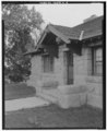 | 4,089 × 5,000 (19.5 MB) | Fæ (talk | contribs) | GWToolset: Creating mediafile for Fæ. HABS 06 July 2014 (611:700) |
You cannot overwrite this file.
File usage on Commons
The following page uses this file: