File:General view of main (west) wall on Columbia Street, original constructed as one building. It became known as three separate buildings, Building -2 brew house, -2A grain handling and -3 HABS KY-177-5.tif

Size of this JPG preview of this TIF file: 485 × 599 pixels. Other resolutions: 194 × 240 pixels | 388 × 480 pixels | 621 × 768 pixels | 829 × 1,024 pixels | 1,657 × 2,048 pixels | 4,366 × 5,395 pixels.
Original file (4,366 × 5,395 pixels, file size: 22.47 MB, MIME type: image/tiff)
Captions
Captions
Add a one-line explanation of what this file represents
Summary edit
| Title |
General view of main (west) wall on Columbia Street, original constructed as one building. It became known as three separate buildings, Building -2 brew house, -2A grain handling and -3 office and labs - George Wiedemann Brewery Complex, Sixth and Columbia Streets, Newport, Campbell County, KY |
|||
| Description |
Samuel Hannaford and Sons; Historic Preservation Associates, Cincinnati, contractor; Calloway, Deborah, transmitter; Peper, Barry, photographer; Mitchell, Fred, historian |
|||
| Depicted place | Kentucky; Campbell County; Newport | |||
| Date | Documentation compiled after 1933 | |||
| Dimensions | 4 x 5 in. | |||
| Current location |
Library of Congress Prints and Photographs Division Washington, D.C. 20540 USA http://hdl.loc.gov/loc.pnp/pp.print |
|||
| Accession number |
HABS KY-177-5 |
|||
| Credit line |
|
|||
| Notes |
|
|||
| Source | https://www.loc.gov/pictures/item/ky0203.photos.209991p | |||
| Permission (Reusing this file) |
|
|||
| Other versions |


| Object location | | View this and other nearby images on: OpenStreetMap |
|---|
File history
Click on a date/time to view the file as it appeared at that time.
| Date/Time | Thumbnail | Dimensions | User | Comment | |
|---|---|---|---|---|---|
| current | 00:48, 20 July 2014 | 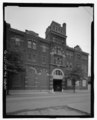 | 4,366 × 5,395 (22.47 MB) | Fæ (talk | contribs) | GWToolset: Creating mediafile for Fæ. HABS 16 July 2014 (1201:1400) |
You cannot overwrite this file.
File usage on Commons
The following 2 pages use this file:
- File:General view of main (west) wall on Columbia Street, original constructed as one building. It became known as three separate buildings, Building -2 brew house, -2A grain handling and -3 HABS KY-177-5.tif
- File:George Wiedemann, General view of main (west) wall on Columbia Street, original constructed as one building. It became known as three separate buildings, Building -2 brew house, -2A grain handling and -3 HABS KY-177-5 (cropped).tif
File usage on other wikis
The following other wikis use this file:
- Usage on de.wikipedia.org