File:Interior view in upper level, from center bay looking southeast - Joseph Parks Farm, Barn, Sharpsburg, Washington County, MD HABS MD,22-SHARP.V,11-A-13.tif

Original file (5,254 × 3,822 pixels, file size: 19.15 MB, MIME type: image/tiff)
Captions
Captions
Summary
edit| Interior view in upper level, from center bay looking southeast - Joseph Parks Farm, Barn, Sharpsburg, Washington County, MD | ||||
|---|---|---|---|---|
| Photographer |
Rosenthal, James W. |
|||
| Title |
Interior view in upper level, from center bay looking southeast - Joseph Parks Farm, Barn, Sharpsburg, Washington County, MD |
|||
| Description |
Wagner, Martha, transmitter; Boucher, Jack E, photographer |
|||
| Depicted place | Maryland; Washington County; Sharpsburg | |||
| Date | Documentation compiled after 1933; 2005 | |||
| Dimensions | 5 x 7 in. | |||
| Current location |
Library of Congress Prints and Photographs Division Washington, D.C. 20540 USA http://hdl.loc.gov/loc.pnp/pp.print |
|||
| Accession number |
HABS MD,22-SHARP.V,11-A-13 |
|||
| Credit line |
|
|||
| Notes |
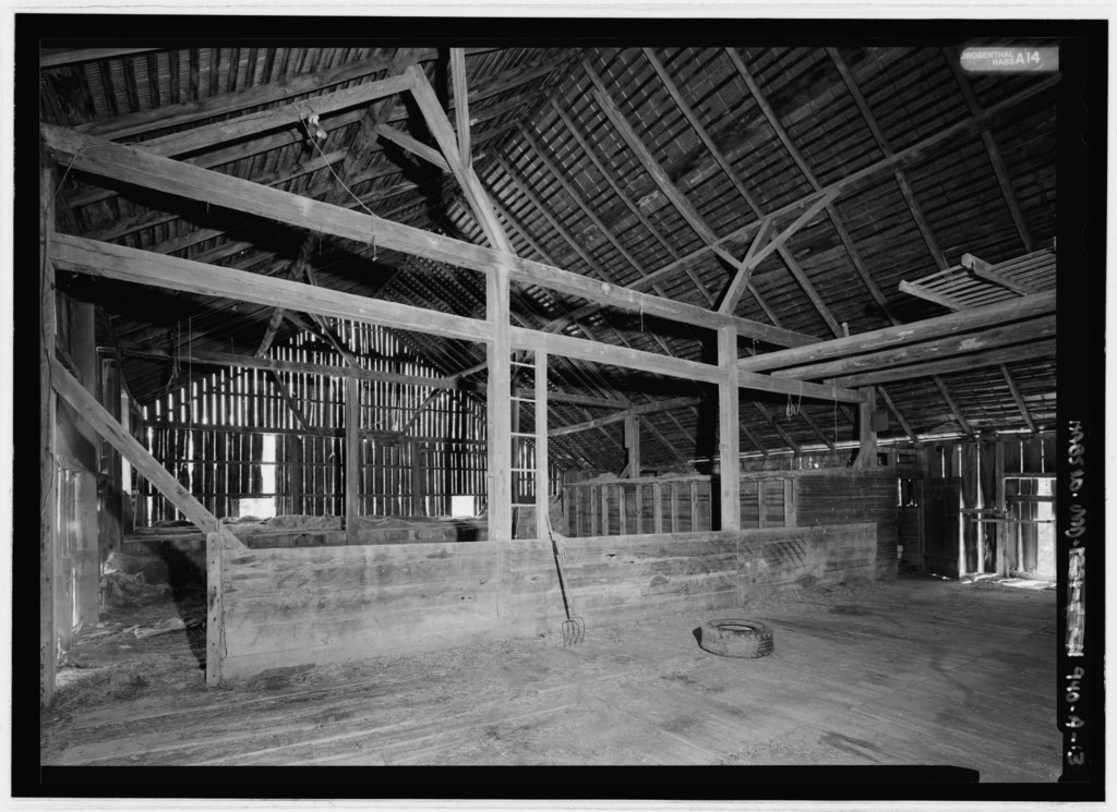
The barn at the Joseph Parks Farm is a good example of a Pennsylvania bank barn, an agricultural building type introduced to the region by Swiss and German settlers in the mid-eighteenth century. Its asymmetrical gable ends identify it as a 'Sweitzer' type barn. The foundation and lower level exterior walls were built of limestone masonry construction. The lower level features a half-open cantilevered forebay along the south side, and housed feeding and milking stalls for livestock. An earthen ramp leads to the upper level on the north side of the barn. The upper level was built of heavy timber construction, with mortise-and-tenon and pegged joints. The barn is sheathed with vertical oak boards of random width. In plan, the upper level housed a central threshing area flanked by two hay/straw mows, with a granary located in the southeast corner.
|
|||
| References |
|
|||
| Source | https://www.loc.gov/pictures/item/md1089.photos.216430p | |||
| Permission (Reusing this file) |
|
|||

| Camera location | | View this and other nearby images on: OpenStreetMap |
|---|
File history
Click on a date/time to view the file as it appeared at that time.
| Date/Time | Thumbnail | Dimensions | User | Comment | |
|---|---|---|---|---|---|
| current | 14:35, 23 July 2014 |  | 5,254 × 3,822 (19.15 MB) | Fæ (talk | contribs) | GWToolset: Creating mediafile for Fæ. HABS 21 July 2014 (1601:1800) |
You cannot overwrite this file.
File usage on Commons
The following page uses this file: