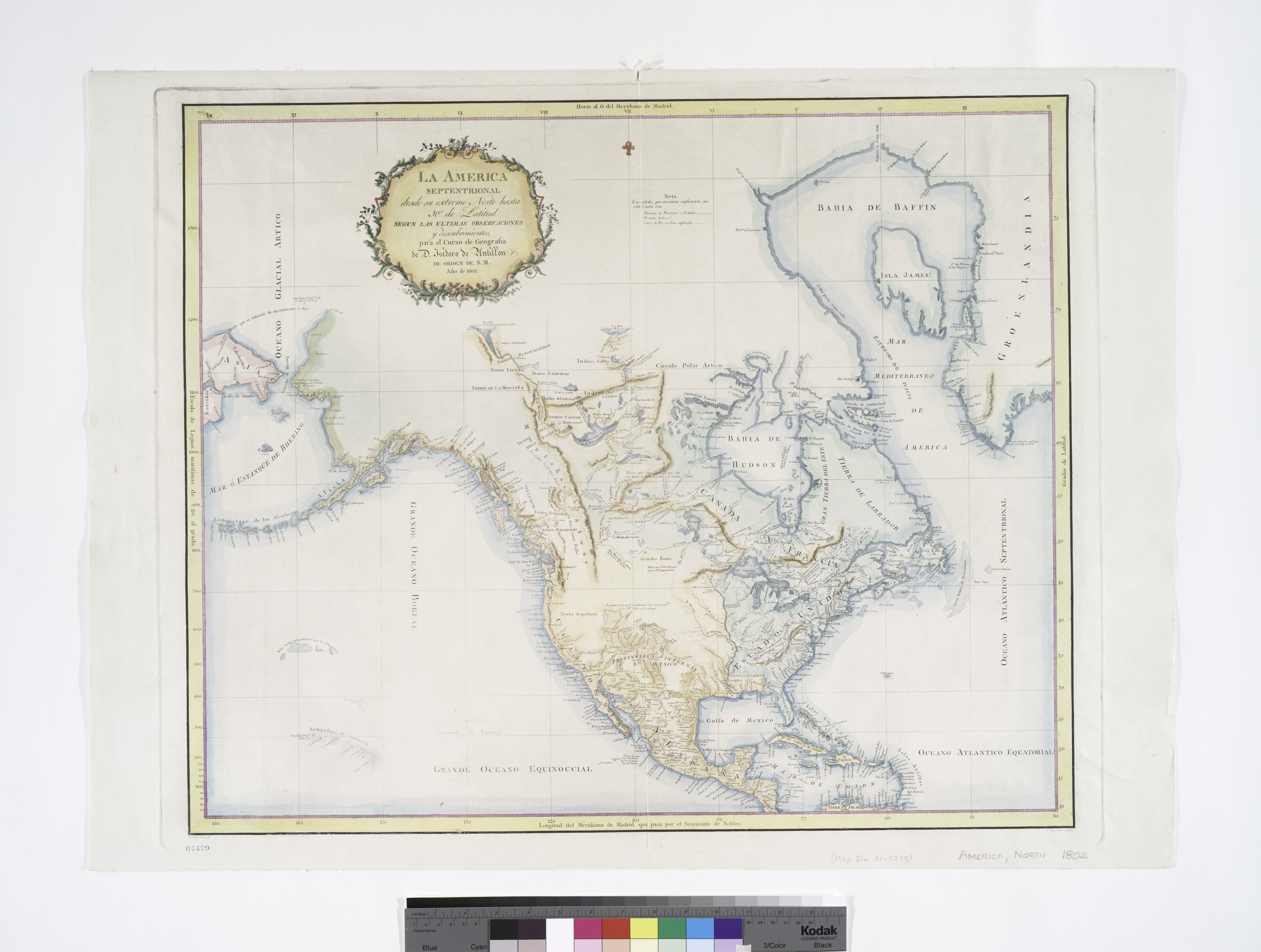
File:La America septentrional, desde su extremo norte hasta 10º de latitud - segun las ultimas observaciones y descubrimientos, para el curso de geografia de D. Isidoro de Antillon de orden de S.M., ñno NYPL434044.tiff

Size of this JPG preview of this TIF file: 794 × 600 pixels. Other resolutions: 318 × 240 pixels | 636 × 480 pixels | 1,017 × 768 pixels | 1,280 × 967 pixels | 2,560 × 1,934 pixels | 5,603 × 4,232 pixels.
Original file (5,603 × 4,232 pixels, file size: 67.88 MB, MIME type: image/tiff)
Captions
Captions
Add a one-line explanation of what this file represents
Summary
edit| Description | La America septentrional, desde su extremo norte hasta 10º de latitud / segun las ultimas observaciones y descubrimientos, para el curso de geografia de D. Isidoro de Antillon de orden de S.M., ñno de 1802 ; F. Selma la grabó ; P. Gangoiti la escribió.; Maps of North America. / Whole | |||||||||||||||||||||||
| Notes | Appears in the author's De Geographia. Madrid, 1804--Wheat. ''Note 2.'') Includes decorative cartouche and notes. ''Note 3.'') Possible 20th century re-strike from original plate? ''Note 4.'') Prime meridian: Madrid. ''Note 5.'') Relief shown pictorially and by hachures. ''Note 6.'') National Endowment for the Humanities Grant for Access to Early Maps of the Middle Atlantic Seaboard. | |||||||||||||||||||||||
| Item physical description | 1 map : hand col. ; 57 x 69 cm. | |||||||||||||||||||||||
| Catalogue call number | Map Div. 01-5239 [Filed with North America, 1802] | |||||||||||||||||||||||
| Standard reference | Phillips 4305; Wheat, C.I. Mapping the transmississippi West, I, 252 | |||||||||||||||||||||||
| Date | circa 1804 | |||||||||||||||||||||||
| Source |
http://digitalgallery.nypl.org/nypldigital/dgkeysearchdetail.cfm?imageID=434044
|
|||||||||||||||||||||||
| Author | Isidoro de, 1778-1814 -- Geographer (not in Relator list) Antillón | |||||||||||||||||||||||
| Permission (Reusing this file) |
From The Lionel Pincus and Princess Firyal Map Division. http://maps.nypl.org
|
|||||||||||||||||||||||
| Location | Stephen A. Schwarzman Building / The Lionel Pincus and Princess Firyal Map Division | |||||||||||||||||||||||
| Digital item published | 2-3-2004; updated 3-25-2011 | |||||||||||||||||||||||
| Digital ID | 434044 | |||||||||||||||||||||||

The making of this file was supported by Wikimedia UK.
To see other files made with the support of Wikimedia UK, please see the category Supported by Wikimedia UK.
|
File history
Click on a date/time to view the file as it appeared at that time.
| Date/Time | Thumbnail | Dimensions | User | Comment | |
|---|---|---|---|---|---|
| current | 15:47, 19 February 2016 |  | 5,603 × 4,232 (67.88 MB) | SteinsplitterBot (talk | contribs) | Bot: Image rotated by 270° |
| 05:06, 2 May 2014 |  | 4,232 × 5,603 (67.85 MB) | Fæ (talk | contribs) | GWToolset:: Creating mediafile for Fæ. Tranche 3 7900-11574 (restart) @ 1 May, 12:43 BST |
You cannot overwrite this file.
File usage on Commons
The following page uses this file: