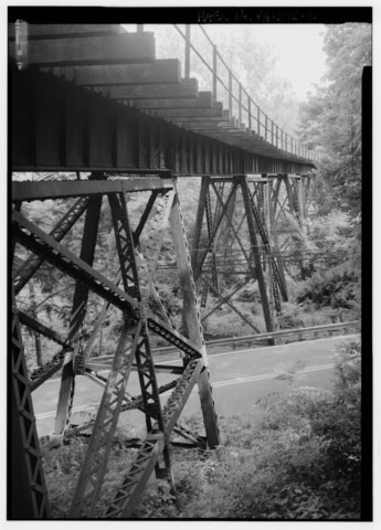
File:Looking south along trestle from north abutment. - Pennsylvania Railroad, Pickering Creek Trestle, Spanning Pickering Creek, south of Buckwalter Road, Pickering, Chester County, PA HAER PA,15-PICK,1-2.tif

Size of this JPG preview of this TIF file: 431 × 600 pixels. Other resolutions: 172 × 240 pixels | 345 × 480 pixels | 552 × 768 pixels | 736 × 1,024 pixels | 1,472 × 2,048 pixels | 3,594 × 5,000 pixels.
Original file (3,594 × 5,000 pixels, file size: 17.14 MB, MIME type: image/tiff)
Captions
Captions
Add a one-line explanation of what this file represents
Summary
edit| Looking south along trestle from north abutment. - Pennsylvania Railroad, Pickering Creek Trestle, Spanning Pickering Creek, south of Buckwalter Road, Pickering, Chester County, PA
( |
||||||||||||||||||||||||
|---|---|---|---|---|---|---|---|---|---|---|---|---|---|---|---|---|---|---|---|---|---|---|---|---|
| Photographer |
Lowe, Jet, creator |
|||||||||||||||||||||||
| Title |
Looking south along trestle from north abutment. - Pennsylvania Railroad, Pickering Creek Trestle, Spanning Pickering Creek, south of Buckwalter Road, Pickering, Chester County, PA |
|||||||||||||||||||||||
| Description |
Carnegie Steel Company; Pennsylvania Railroad; Consolidated Rail Corporation (Conrail); Norfolk Southern Railroad; DeLony, Eric N, project manager; Pennsylvania Historical and Museum Commission, sponsor; Consolidated Rail Corporation (Conrail), sponsor; Spivey, Justin M, historian; Lowe, Jet, photographer |
|||||||||||||||||||||||
| Depicted place | Pennsylvania; Chester County; Pickering | |||||||||||||||||||||||
| Date | 1999 | |||||||||||||||||||||||
| Dimensions | height: 7 in (17.7 cm); width: 5 in (12.7 cm) | |||||||||||||||||||||||
| Collection |
|
|||||||||||||||||||||||
| Current location |
Library of Congress Prints and Photographs Division Washington, D.C. 20540 USA http://hdl.loc.gov/loc.pnp/pp.print |
|||||||||||||||||||||||
| Accession number |
HAER PA,15-PICK,1-2 |
|||||||||||||||||||||||
| Credit line |
|
|||||||||||||||||||||||
| Notes |
|
|||||||||||||||||||||||
| Source | https://www.loc.gov/pictures/item/pa3727.photos.361991p | |||||||||||||||||||||||
| Permission (Reusing this file) |
|
|||||||||||||||||||||||


| Camera location | | View this and other nearby images on: OpenStreetMap |
|---|
File history
Click on a date/time to view the file as it appeared at that time.
| Date/Time | Thumbnail | Dimensions | User | Comment | |
|---|---|---|---|---|---|
| current | 06:06, 1 August 2014 |  | 3,594 × 5,000 (17.14 MB) | Fæ (talk | contribs) | GWToolset: Creating mediafile for Fæ. HABS 31 July 2014 (3000:3200) |
You cannot overwrite this file.
File usage on Commons
The following page uses this file: