File:Morning view, contextual view of the exterior west side of the north wall along the unpaved road; camera facing west, positioned in road approximately 8 posts west of the gate. - HALS SC-1-A-16.tif

Size of this JPG preview of this TIF file: 734 × 600 pixels. Other resolutions: 294 × 240 pixels | 588 × 480 pixels | 940 × 768 pixels | 1,253 × 1,024 pixels | 2,507 × 2,048 pixels | 5,221 × 4,266 pixels.
Original file (5,221 × 4,266 pixels, file size: 21.24 MB, MIME type: image/tiff)
Captions
Captions
Add a one-line explanation of what this file represents
Summary edit
| Photographer |
White, Lee Ann, creator |
|||
| Title |
Morning view, contextual view of the exterior west side of the north wall along the unpaved road; camera facing west, positioned in road approximately 8 posts west of the gate. - Beaufort National Cemetery, Wall, 1601 Boundary Street, Beaufort, Beaufort County, SC |
|||
| Description |
U.S. Department of Veterans Affairs; The Jaeger Company, sponsor; Jaeger, Dale, landscape architect; Rushing, Luke, landscape architect; LaBrie, Brian, historian |
|||
| Depicted place | South Carolina; Beaufort County; Beaufort | |||
| Date | 2006 | |||
| Dimensions | 4 x 5 in. | |||
| Current location |
Library of Congress Prints and Photographs Division Washington, D.C. 20540 USA http://hdl.loc.gov/loc.pnp/pp.print |
|||
| Accession number |
HALS SC-1-A-16 |
|||
| Credit line |
|
|||
| Notes |
|
|||
| References |
|
|||
| Source | https://www.loc.gov/pictures/item/sc1147.photos.365401p | |||
| Permission (Reusing this file) |
|

File history
Click on a date/time to view the file as it appeared at that time.
| Date/Time | Thumbnail | Dimensions | User | Comment | |
|---|---|---|---|---|---|
| current | 21:32, 1 August 2014 | 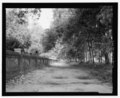 | 5,221 × 4,266 (21.24 MB) | Fæ (talk | contribs) | GWToolset: Creating mediafile for Fæ. HABS 2014-08-01 (3201:3400) |
You cannot overwrite this file.
File usage on Commons
The following page uses this file: