File:North America, performed under the patronage of Louis Duke of Orleans, First Prince of the Blood; LOC 74694275.jpg

Size of this preview: 585 × 599 pixels. Other resolutions: 234 × 240 pixels | 469 × 480 pixels | 750 × 768 pixels | 1,000 × 1,024 pixels | 2,000 × 2,048 pixels | 10,688 × 10,944 pixels.
Original file (10,688 × 10,944 pixels, file size: 17.21 MB, MIME type: image/jpeg)
Captions
Captions
Add a one-line explanation of what this file represents
Summary edit
| Warning | The original file is very high-resolution. It might not load properly or could cause your browser to freeze when opened at full size. |
|---|
| Description |
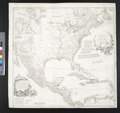
English: Scale ca. 1:6,000,000. Hand colored. Relief shown pictorially. Shows provinces, cities and towns, forts, Indian villages and tribal territory. Also shows shoals, banks, and other navigational hazards off the coast of Nova Scotia and in the Caribbean area. Originally issued in 4 plates. LC copy mounted as 1 map. LC Maps of North America, 1750-1789, 13 "N.B. This large map of North America was originally engrav'd at Paris, ..." Includes historical and descriptive notes, and an inset chart of Baffin Bay and Hudson Bay. Available also through the Library of Congress Web site as a raster image. Vault AACR2: 100; 651/1; 700/1; 700/2; 700/3; 710/6 |
||||||||||||||||||||||||||||||||||||
| Title | North America, performed under the patronage of Louis Duke of Orleans, First Prince of the Blood; | ||||||||||||||||||||||||||||||||||||
| Shelf ID | G3300 1752 .B62 | ||||||||||||||||||||||||||||||||||||
| Date | |||||||||||||||||||||||||||||||||||||
| Source | https://www.loc.gov/item/74694275/ | ||||||||||||||||||||||||||||||||||||
| Author |
|
||||||||||||||||||||||||||||||||||||
| Permission (Reusing this file) |
|
||||||||||||||||||||||||||||||||||||
| Other versions |
|
||||||||||||||||||||||||||||||||||||
| Location | North America | ||||||||||||||||||||||||||||||||||||
| Part of | Military Battles And Campaigns · American Memory · Catalog · Geography And Map Division · American Revolution And Its Era: Maps And Charts Of North America And The West Indies, 1750-1789 | ||||||||||||||||||||||||||||||||||||
| Subject | North America · Maps · Early Works To 1800 | ||||||||||||||||||||||||||||||||||||


.jpg)

Licensing edit
|
This is a faithful photographic reproduction of a two-dimensional, public domain work of art. The work of art itself is in the public domain for the following reason:
The official position taken by the Wikimedia Foundation is that "faithful reproductions of two-dimensional public domain works of art are public domain".
This photographic reproduction is therefore also considered to be in the public domain in the United States. In other jurisdictions, re-use of this content may be restricted; see Reuse of PD-Art photographs for details. | ||||
File history
Click on a date/time to view the file as it appeared at that time.
| Date/Time | Thumbnail | Dimensions | User | Comment | |
|---|---|---|---|---|---|
| current | 20:54, 8 June 2018 | | 10,688 × 10,944 (17.21 MB) | Fæ (talk | contribs) | LOC Maps https://www.loc.gov/item/74694275/ #24134 |
You cannot overwrite this file.
File usage on Commons
The following 5 pages use this file:
- File:North America. LOC 75693503.jpg
- File:North America. LOC 75693503.tif
- File:North America. Performed under the patronage of Louis, Duke of Orléans (d'Anville, Seale, etc.).jpg
- File:North America - performed under the patronage of Louis Duke of Orleans, First Prince of the Blood by the Sieur d'Anville; greatly improved by Mr. Bolton; engrav,d by R. W. Seale; Gravelot, NYPL489836.tiff
- File:North America performed under the patronage of Louis Duke of Orleans, First Prince of the Blood by the Sieur d'Anville - greatly improved by Mr. Bolton; engrav,d by R. W. Seale; Gravelot, NYPL434597.tiff