File:Nova Belgica et Anglia Nova. NYPL433980.tiff

Size of this JPG preview of this TIF file: 800 × 520 pixels. Other resolutions: 320 × 208 pixels | 640 × 416 pixels | 1,024 × 666 pixels | 1,280 × 832 pixels | 2,560 × 1,664 pixels | 6,203 × 4,032 pixels.
Original file (6,203 × 4,032 pixels, file size: 71.59 MB, MIME type: image/tiff)
Captions
Captions
Add a one-line explanation of what this file represents
Summary
edit| Description | Nova Belgica et Anglia Nova.; Maps of North America. / Countries / United States (except New York) / Parts | |||||||||||||||||||||||
| Notes | Accompanied by text: Anglia Nova ([2] p. ; 49 x 30 cm.). NN ''Note 2.'') Appears in Willem and Joan Blaeu's Theatrum orbis terrarum, sive Atlas Novus, 1640 and other eds. ''Note 3.'') Covers New England and the Middle Atlantic states from Penobscot Bay south to the mouth of Chesapeake Bay. ''Note 4.'') Includes decorative cartouche and ill. ''Note 5.'') National Endowment for the Humanities Grant for Access to Early Maps of the Middle Atlantic Seaboard. ''Note 6.'') Relief shown pictorially. ''Note 7.'') Text on verso: Belgica Nova et Nova Anglia. ''Note 8.'') Oriented with north to the right. | |||||||||||||||||||||||
| Item physical description | 1 map : hand col. ; 37 x 48 cm. | |||||||||||||||||||||||
| Catalogue call number | Map Div. 01-1923 [Map and accompanying text encapsulated together and filed with New York Province, 1658] | |||||||||||||||||||||||
| Standard reference | Deák 027; Koeman, C. Atlantes Neerlandici, I, p. 130; Stokes, I.N.P. Iconography of Manhattan Island, II, p. 143-144; Burden, P.D. Mapping of North America, 241 | |||||||||||||||||||||||
| Date | circa 1640 | |||||||||||||||||||||||
| Source |
http://digitalgallery.nypl.org/nypldigital/dgkeysearchdetail.cfm?imageID=433980
|
|||||||||||||||||||||||
| Author | Willem Janszoon, 1571-1638 -- Cartographer Blaeu | |||||||||||||||||||||||
| Permission (Reusing this file) |
From The Lionel Pincus and Princess Firyal Map Division. http://maps.nypl.org
|
|||||||||||||||||||||||
| Location | Stephen A. Schwarzman Building / The Lionel Pincus and Princess Firyal Map Division | |||||||||||||||||||||||
| Digital item published | 2-3-2004; updated 3-25-2011 | |||||||||||||||||||||||
| Digital ID | 433980 | |||||||||||||||||||||||

The making of this file was supported by Wikimedia UK.
To see other files made with the support of Wikimedia UK, please see the category Supported by Wikimedia UK.
|
File history
Click on a date/time to view the file as it appeared at that time.
| Date/Time | Thumbnail | Dimensions | User | Comment | |
|---|---|---|---|---|---|
| current | 16:08, 19 February 2016 |  | 6,203 × 4,032 (71.59 MB) | SteinsplitterBot (talk | contribs) | Bot: Image rotated by 270° |
| 20:34, 2 May 2014 | 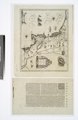 | 4,032 × 6,203 (71.56 MB) | Fæ (talk | contribs) | GWToolset:: Creating mediafile for Fæ. Tranche 3 11591-16518 @ 2 May, 06:47 BST |
You cannot overwrite this file.
File usage on Commons
There are no pages that use this file.