File:ProvincesOfTheNetherlands.gif
No higher resolution available.
ProvincesOfTheNetherlands.gif (201 × 291 pixels, file size: 47 KB, MIME type: image/gif, looped, 12 frames, 11 s)
Captions
Captions
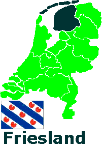
Flags and positions of the 12 provinces on the map of the Netherlands.
Summary
edit| Description | Provinces of the Netherlands |
| Date | |
| Source | Own work |
| Author | Abnormaal |
| Permission (Reusing this file) |
This is Free to use copy or change, edited mercilessly and redistributed at will. |
| Other versions |
|
Clickable version
edit
Licensing
edit| I, the copyright holder of this work, release this work into the public domain. This applies worldwide. In some countries this may not be legally possible; if so: I grant anyone the right to use this work for any purpose, without any conditions, unless such conditions are required by law. |
| Annotations | This image is annotated: View the annotations at Commons |


File history
Click on a date/time to view the file as it appeared at that time.
| Date/Time | Thumbnail | Dimensions | User | Comment | |
|---|---|---|---|---|---|
| current | 00:01, 26 January 2006 | | 201 × 291 (47 KB) | Abnormaal (talk | contribs) | More info in one picture. Edit mercilessly and redistributed at will |
You cannot overwrite this file.
File usage on Commons
The following 15 pages use this file:
- Atlas of the Netherlands
- File:Drenthe - 2.png
- File:Flevoland.GIF
- File:Friesland.GIF
- File:Gelderland.GIF
- File:Groningen.GIF
- File:Limburg.GIF
- File:Noord Holland.GIF
- File:Noord brabant.GIF
- File:Overijssel.GIF
- File:ProvincesOfTheNetherlands.gif
- File:Utrecht.GIF
- File:Zeeland.GIF
- File:Zuid Holland.GIF
- Category:Flags of provinces of the Netherlands
File usage on other wikis
The following other wikis use this file:
- Usage on an.wikipedia.org
- Usage on az.wikipedia.org
- Usage on be.wikipedia.org
- Usage on ca.wikipedia.org
- Usage on es.wikipedia.org
- Usage on eu.wikipedia.org
- Usage on nl.wikipedia.org
- Usage on oc.wikipedia.org
- Usage on roa-tara.wikipedia.org
- Usage on ru.wikipedia.org
- Usage on uk.wikipedia.org