File:Snow Hill, State Route 40, Carsley, Surry County, VA HABS VA,91-0TT.V,1- (sheet 7 of 10).tif

Size of this JPG preview of this TIF file: 758 × 599 pixels. Other resolutions: 304 × 240 pixels | 607 × 480 pixels | 971 × 768 pixels | 1,280 × 1,012 pixels | 2,560 × 2,024 pixels | 9,632 × 7,616 pixels.
Original file (9,632 × 7,616 pixels, file size: 454 KB, MIME type: image/tiff)
Captions
Captions
Add a one-line explanation of what this file represents
Summary edit
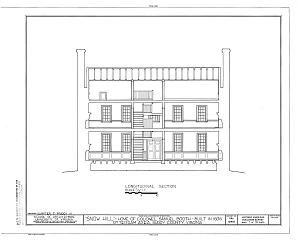
| HABS VA,91-0TT.V,1- (sheet 7 of 10) - Snow Hill, State Route 40, Carsley, Surry County, VA | ||||
|---|---|---|---|---|
| Title |
HABS VA,91-0TT.V,1- (sheet 7 of 10) - Snow Hill, State Route 40, Carsley, Surry County, VA |
|||
| Depicted place | Virginia; Surry County; Carsley | |||
| Date | Documentation compiled after 1933 | |||
| Dimensions | 19 x 24 in. (B size) | |||
| Current location |
Library of Congress Prints and Photographs Division Washington, D.C. 20540 USA http://hdl.loc.gov/loc.pnp/pp.print |
|||
| Accession number |
HABS VA,91-0TT.V,1- (sheet 7 of 10) |
|||
| Credit line |
|
|||
| Notes |
|
|||
| References |
|
|||
| Source | https://www.loc.gov/pictures/item/va0455.sheet.00007a | |||
| Permission (Reusing this file) |
|
|||

File history
Click on a date/time to view the file as it appeared at that time.
| Date/Time | Thumbnail | Dimensions | User | Comment | |
|---|---|---|---|---|---|
| current | 07:02, 4 August 2014 |  | 9,632 × 7,616 (454 KB) | Fæ (talk | contribs) | GWToolset: Creating mediafile for Fæ. HABS 2014-08-02 (3401:3600) |
You cannot overwrite this file.
File usage on Commons
The following page uses this file: