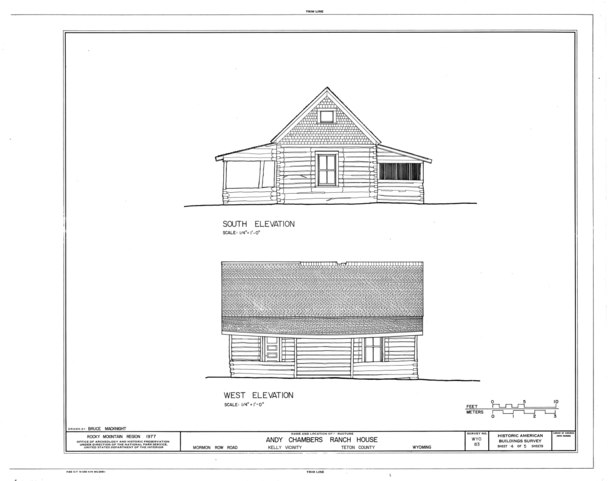
File:South and West Elevations - Andy Chambers Homestead, 0.4 mile south of Antelope Flats Road on the east side of Mormon Row Road, Kelly, Teton County, WY HABS WYO,20-KEL.V,1- (sheet 4 of 5).tif

Size of this JPG preview of this TIF file: 765 × 599 pixels. Other resolutions: 307 × 240 pixels | 613 × 480 pixels | 981 × 768 pixels | 1,280 × 1,003 pixels | 2,560 × 2,005 pixels | 9,722 × 7,616 pixels.
Original file (9,722 × 7,616 pixels, file size: 577 KB, MIME type: image/tiff)
Captions
Captions
Add a one-line explanation of what this file represents
Summary edit
| South and West Elevations - Andy Chambers Homestead, 0.4 mile south of Antelope Flats Road on the east side of Mormon Row Road, Kelly, Teton County, WY | ||||
|---|---|---|---|---|
| Photographer |
MacKnight, Bruce, creator |
|||
| Title |
South and West Elevations - Andy Chambers Homestead, 0.4 mile south of Antelope Flats Road on the east side of Mormon Row Road, Kelly, Teton County, WY |
|||
| Depicted place | Wyoming; Teton County; Kelly | |||
| Date | 1977 | |||
| Dimensions | 19 x 24 in. (B size) | |||
| Current location |
Library of Congress Prints and Photographs Division Washington, D.C. 20540 USA http://hdl.loc.gov/loc.pnp/pp.print |
|||
| Accession number |
HABS WYO,20-KEL.V,1- (sheet 4 of 5) |
|||
| Credit line |
|
|||
| Notes |
|
|||
| Source | https://www.loc.gov/pictures/item/wy0032.sheet.00004a | |||
| Permission (Reusing this file) |
|
|||

File history
Click on a date/time to view the file as it appeared at that time.
| Date/Time | Thumbnail | Dimensions | User | Comment | |
|---|---|---|---|---|---|
| current | 00:41, 5 August 2014 |  | 9,722 × 7,616 (577 KB) | Fæ (talk | contribs) | GWToolset: Creating mediafile for Fæ. HABS 2014-08-04 3801-4000 |
You cannot overwrite this file.
File usage on Commons
The following page uses this file: