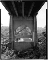
File:VIEW OF BRIDGE FROM UNDERNEATH SHOWING CONCRETE PIER AND CONCRETE DECK SUPPORT SYSTEM, LOOKING NORTHWEST - Cotter Bridge, Spanning White River at U.S. Highway 62, Cotter, Baxter HAER ARK,3-COT,1-7.tif

Size of this JPG preview of this TIF file: 482 × 600 pixels. Other resolutions: 193 × 240 pixels | 386 × 480 pixels | 617 × 768 pixels | 823 × 1,024 pixels | 1,646 × 2,048 pixels | 4,020 × 5,000 pixels.
Original file (4,020 × 5,000 pixels, file size: 19.17 MB, MIME type: image/tiff)
Captions
Captions
Add a one-line explanation of what this file represents
Summary edit
| VIEW OF BRIDGE FROM UNDERNEATH SHOWING CONCRETE PIER AND CONCRETE DECK SUPPORT SYSTEM, LOOKING NORTHWEST - Cotter Bridge, Spanning White River at U.S. Highway 62, Cotter, Baxter County, AR | ||||
|---|---|---|---|---|
| Photographer |
Taft, Louise, creator |
|||
| Title |
VIEW OF BRIDGE FROM UNDERNEATH SHOWING CONCRETE PIER AND CONCRETE DECK SUPPORT SYSTEM, LOOKING NORTHWEST - Cotter Bridge, Spanning White River at U.S. Highway 62, Cotter, Baxter County, AR |
|||
| Depicted place | Arkansas; Baxter County; Cotter | |||
| Date | 1988 | |||
| Dimensions | 4 x 5 in. | |||
| Current location |
Library of Congress Prints and Photographs Division Washington, D.C. 20540 USA http://hdl.loc.gov/loc.pnp/pp.print |
|||
| Accession number |
HAER ARK,3-COT,1-7 |
|||
| Credit line |
|
|||
| Source | https://www.loc.gov/pictures/item/ar0073.photos.010206p | |||
| Permission (Reusing this file) |
|
|||

| Camera location | | View this and other nearby images on: OpenStreetMap |
|---|
File history
Click on a date/time to view the file as it appeared at that time.
| Date/Time | Thumbnail | Dimensions | User | Comment | |
|---|---|---|---|---|---|
| current | 09:08, 27 June 2014 |  | 4,020 × 5,000 (19.17 MB) | Fæ (talk | contribs) | GWToolset: Creating mediafile for Fæ. HABS batch upload 26 June 2014 (151:200) |
You cannot overwrite this file.
File usage on Commons
The following page uses this file: