File:Virginius Island Waterpowered Mill Complex, North bank of Shenandoah River 0.5 mile from confluence with Potomac River, Harpers Ferry, Jefferson County, WV HAER WVA,19-HARF,34- (sheet 2 of 8).tif
Size of this JPG preview of this TIF file: 800 × 545 pixels. Other resolutions: 320 × 218 pixels | 640 × 436 pixels | 1,024 × 698 pixels | 1,280 × 873 pixels | 2,560 × 1,745 pixels | 14,420 × 9,830 pixels.
Original file (14,420 × 9,830 pixels, file size: 394 KB, MIME type: image/tiff)
Captions
Captions
Add a one-line explanation of what this file represents
Summary edit
| Warning | The original file is very high-resolution. It might not load properly or could cause your browser to freeze when opened at full size. |
|---|
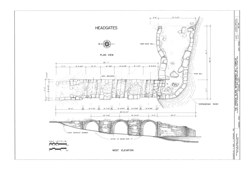
| HAER WVA,19-HARF,34- (sheet 2 of 8) - Virginius Island Waterpowered Mill Complex, North bank of Shenandoah River 0.5 mile from confluence with Potomac River, Harpers Ferry, Jefferson County, WV | ||||
|---|---|---|---|---|
| Title |
HAER WVA,19-HARF,34- (sheet 2 of 8) - Virginius Island Waterpowered Mill Complex, North bank of Shenandoah River 0.5 mile from confluence with Potomac River, Harpers Ferry, Jefferson County, WV |
|||
| Description |
O'Connell, Kristen, transmitter; O'Connell, Kristen, transmitter; Winant, E, delineator; Spyrakos, C, delineator; Ross, P, delineator; Bonenberger, D, delineator; Jordan, B, delineator; Birdsong, S, delineator; Kierstead, M, delineator; Coffey, B, delineator |
|||
| Depicted place | West Virginia; Jefferson County; Harpers Ferry | |||
| Date | Documentation compiled after 1968 | |||
| Dimensions | 24 x 36 in. (D size) | |||
| Current location |
Library of Congress Prints and Photographs Division Washington, D.C. 20540 USA http://hdl.loc.gov/loc.pnp/pp.print |
|||
| Accession number |
HAER WVA,19-HARF,34- (sheet 2 of 8) |
|||
| Credit line |
|
|||
| Notes |
|
|||
| Source | https://www.loc.gov/pictures/item/wv0536.sheet.00002a | |||
| Permission (Reusing this file) |
|
|||

File history
Click on a date/time to view the file as it appeared at that time.
| Date/Time | Thumbnail | Dimensions | User | Comment | |
|---|---|---|---|---|---|
| current | 23:27, 4 August 2014 |  | 14,420 × 9,830 (394 KB) | Fæ (talk | contribs) | GWToolset: Creating mediafile for Fæ. HABS 2014-08-04 3801-4000 |
You cannot overwrite this file.
File usage on Commons
The following page uses this file: